You are here: Home > Network List > UU - University of Utah Regional Network Stations List
> Station BSUT Blindstream Canyon, Hanna, UT, USA > Earthquake Result Viewer
BSUT Blindstream Canyon, Hanna, UT, USA - Earthquake Result Viewer
| Earthquake location: |
Peru-Ecuador Border Region |
| Earthquake latitude/longitude: |
-4.1/-80.4 |
| Earthquake time(UTC): |
2017/06/05 (156) 11:34:11 GMT |
| Earthquake Depth: |
51 km |
| Earthquake Magnitude: |
5.6 Mww |
| Earthquake Catalog/Contributor: |
NEIC PDE/us |
|
| Network: |
UU University of Utah Regional Network |
| Station: |
BSUT Blindstream Canyon, Hanna, UT, USA |
| Lat/Lon: |
40.54 N/110.76 W |
| Elevation: |
3211 m |
|
| Distance: |
52.4 deg |
| Az: |
330.902 deg |
| Baz: |
140.472 deg |
| Ray Param: |
0.066643745 |
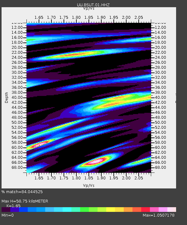
| Estimated Moho Depth: |
58.75 km |
| Estimated Crust Vp/Vs: |
1.65 |
| Assumed Crust Vp: |
6.155 km/s |
| Estimated Crust Vs: |
3.73 km/s |
| Estimated Crust Poisson's Ratio: |
0.21 |
|
| Radial Match: |
84.044525 % |
| Radial Bump: |
400 |
| Transverse Match: |
53.074013 % |
| Transverse Bump: |
400 |
| SOD ConfigId: |
2140511 |
| Insert Time: |
2017-06-19 03:30:59.401 +0000 |
| GWidth: |
2.5 |
| Max Bumps: |
400 |
| Tol: |
0.001 |
|

Signal To Noise
| Channel | StoN | STA | LTA |
| UU:BSUT:01:HHZ:20170605T11:42:48.078005Z | 11.059384 | 2.832288E-8 | 2.5609814E-9 |
| UU:BSUT:01:HHN:20170605T11:42:48.078005Z | 1.9055647 | 9.8149E-9 | 5.150652E-9 |
| UU:BSUT:01:HHE:20170605T11:42:48.078005Z | 2.6220884 | 1.0073255E-8 | 3.841692E-9 |
| Arrivals |
| Ps | 6.5 SECOND |
| PpPs | 24 SECOND |
| PsPs/PpSs | 31 SECOND |


