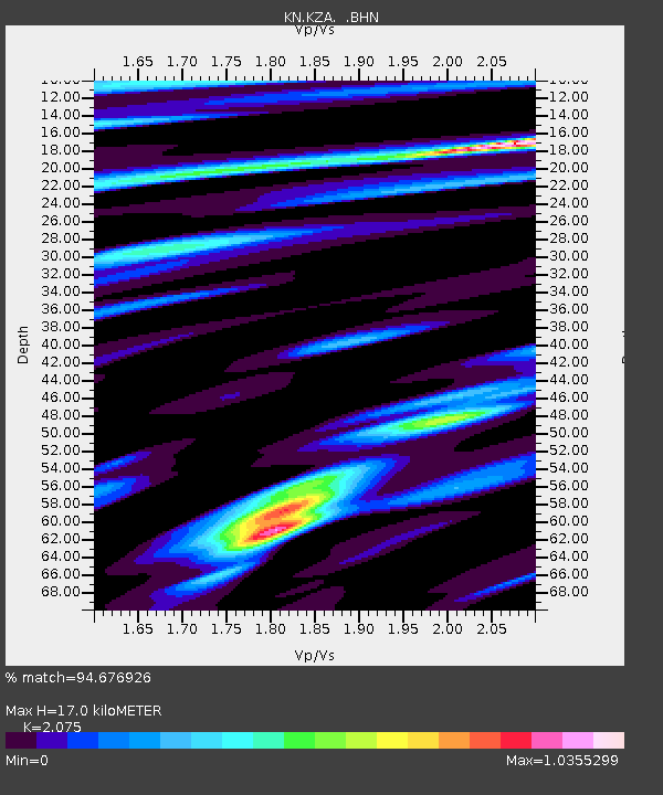
KZA KN.KZA - Earthquake Result Viewer
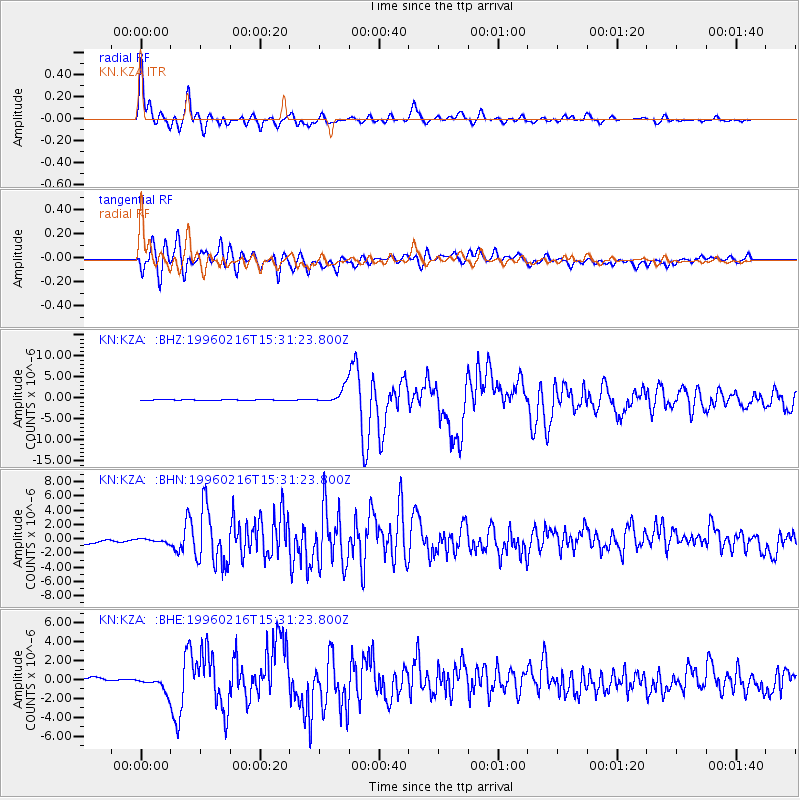
Earthquake location: Off East Coast Of Honshu, Japan
Earthquake latitude/longitude: 37.3/142.5
Earthquake time(UTC): 1996/02/16 (047) 15:22:57 GMT
Earthquake Depth: 33 km
Earthquake Magnitude: 6.2 MB, 6.2 MS, 6.7 UNKNOWN, 6.6 MW
Earthquake Catalog/Contributor: WHDF/NEIC
Network: KN Kyrgyz Seismic Telemetry Network
Station: KZA KN.KZA
Lat/Lon: 42.08 N/75.25 E
Elevation: 3520 m
Distance: 50.7 deg
Az: 297.546 deg
Baz: 71.654 deg
Ray Param: 0.06779519
Estimated Moho Depth: 17.0 km
Estimated Crust Vp/Vs: 2.08
Assumed Crust Vp: 6.306 km/s
Estimated Crust Vs: 3.039 km/s
Estimated Crust Poisson's Ratio: 0.35
Radial Match: 94.676926 %
Radial Bump: 400
Transverse Match: 88.66446 %
Transverse Bump: 400
SOD ConfigId: 6273
Insert Time: 2010-03-08 20:38:24.281 +0000
GWidth: 2.5
Max Bumps: 400
Tol: 0.001

Signal To Noise

ChannelStoNSTALTA
KN:KZA: :BHN:19960216T15:31:23.800Z0.79484262.8177612E-73.5450557E-7
KN:KZA: :BHE:19960216T15:31:23.800Z2.02661787.027598E-73.4676484E-7
KN:KZA: :BHZ:19960216T15:31:23.800Z17.3028741.9305849E-61.1157597E-7
Arrivals
Ps3.0 SECOND
PpPs7.9 SECOND
PsPs/PpSs11 SECOND