You are here: Home > Network List > US - United States National Seismic Network Stations List
> Station AMTX Amarillo, Texas, USA > Earthquake Result Viewer
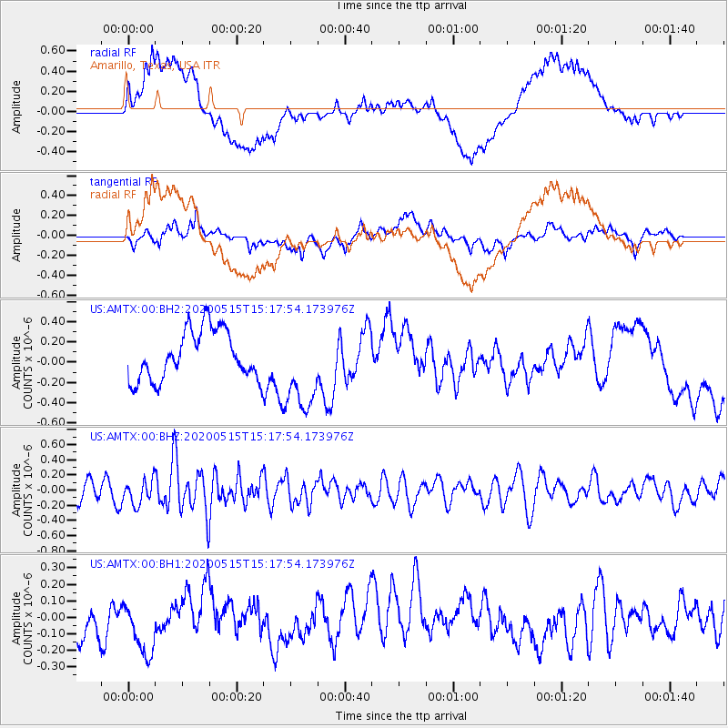
AMTX Amarillo, Texas, USA - Earthquake Result Viewer
*The percent match for this event was below the threshold and hence no stack was calculated.
| Earthquake location: |
Samoa Islands Region |
| Earthquake latitude/longitude: |
-15.8/-172.9 |
| Earthquake time(UTC): |
2020/05/15 (136) 15:05:55 GMT |
| Earthquake Depth: |
19 km |
| Earthquake Magnitude: |
5.6 Mww |
| Earthquake Catalog/Contributor: |
NEIC PDE/us |
|
| Network: |
US United States National Seismic Network |
| Station: |
AMTX Amarillo, Texas, USA |
| Lat/Lon: |
34.53 N/101.41 W |
| Elevation: |
1010 m |
|
| Distance: |
84.3 deg |
| Az: |
51.886 deg |
| Baz: |
246.562 deg |
| Ray Param: |
$rayparam |
*The percent match for this event was below the threshold and hence was not used in the summary stack. |
|
| Radial Match: |
57.904522 % |
| Radial Bump: |
400 |
| Transverse Match: |
56.922695 % |
| Transverse Bump: |
400 |
| SOD ConfigId: |
21166931 |
| Insert Time: |
2020-06-13 14:32:49.742 +0000 |
| GWidth: |
2.5 |
| Max Bumps: |
400 |
| Tol: |
0.001 |
|
Signal To Noise
| Channel | StoN | STA | LTA |
| US:AMTX:00:BHZ:20200515T15:17:54.173976Z | 1.1261952 | 1.6166977E-7 | 1.4355395E-7 |
| US:AMTX:00:BH1:20200515T15:17:54.173976Z | 1.7079229 | 1.7276827E-7 | 1.0115694E-7 |
| US:AMTX:00:BH2:20200515T15:17:54.173976Z | 1.6746039 | 4.1147976E-7 | 2.4571764E-7 |
| Arrivals |
| Ps | |
| PpPs | |
| PsPs/PpSs | |


