You are here: Home > Network List > UU - University of Utah Regional Network Stations List
> Station KNB Kanab, UT, USA > Earthquake Result Viewer
KNB Kanab, UT, USA - Earthquake Result Viewer

| Earthquake location: |
Peru-Ecuador Border Region |
| Earthquake latitude/longitude: |
-4.1/-80.4 |
| Earthquake time(UTC): |
2017/06/05 (156) 11:34:11 GMT |
| Earthquake Depth: |
51 km |
| Earthquake Magnitude: |
5.6 Mww |
| Earthquake Catalog/Contributor: |
NEIC PDE/us |
|
| Network: |
UU University of Utah Regional Network |
| Station: |
KNB Kanab, UT, USA |
| Lat/Lon: |
37.02 N/112.82 W |
| Elevation: |
1715 m |
|
| Distance: |
50.9 deg |
| Az: |
326.391 deg |
| Baz: |
136.385 deg |
| Ray Param: |
0.06764933 |
| Estimated Moho Depth: |
32.75 km |
| Estimated Crust Vp/Vs: |
1.88 |
| Assumed Crust Vp: |
6.194 km/s |
| Estimated Crust Vs: |
3.286 km/s |
| Estimated Crust Poisson's Ratio: |
0.30 |
|
| Radial Match: |
88.13259 % |
| Radial Bump: |
380 |
| Transverse Match: |
77.71008 % |
| Transverse Bump: |
398 |
| SOD ConfigId: |
2140511 |
| Insert Time: |
2017-06-19 03:31:11.239 +0000 |
| GWidth: |
2.5 |
| Max Bumps: |
400 |
| Tol: |
0.001 |
|
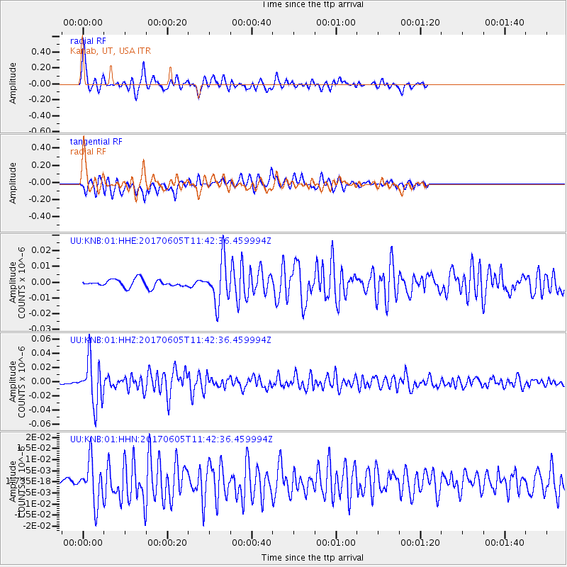
Signal To Noise
| Channel | StoN | STA | LTA |
| UU:KNB:01:HHZ:20170605T11:42:36.459994Z | 11.862904 | 3.1703323E-8 | 2.672476E-9 |
| UU:KNB:01:HHN:20170605T11:42:36.459994Z | 3.9888124 | 9.643384E-9 | 2.4176077E-9 |
| UU:KNB:01:HHE:20170605T11:42:36.459994Z | 5.790919 | 1.3712895E-8 | 2.3679998E-9 |
| Arrivals |
| Ps | 4.9 SECOND |
| PpPs | 15 SECOND |
| PsPs/PpSs | 19 SECOND |


