You are here: Home > Network List > KN - Kyrgyz Seismic Telemetry Network Stations List
> Station KZA KN.KZA > Earthquake Result Viewer
KZA KN.KZA - Earthquake Result Viewer
| Earthquake location: |
Mindanao, Philippines |
| Earthquake latitude/longitude: |
6.3/124.0 |
| Earthquake time(UTC): |
2005/11/30 (334) 16:53:42 GMT |
| Earthquake Depth: |
13 km |
| Earthquake Magnitude: |
5.8 MB, 5.9 MS, 6.3 MW, 6.2 MW |
| Earthquake Catalog/Contributor: |
WHDF/NEIC |
|
| Network: |
KN Kyrgyz Seismic Telemetry Network |
| Station: |
KZA KN.KZA |
| Lat/Lon: |
42.08 N/75.25 E |
| Elevation: |
3520 m |
|
| Distance: |
55.9 deg |
| Az: |
317.471 deg |
| Baz: |
115.496 deg |
| Ray Param: |
0.064461626 |
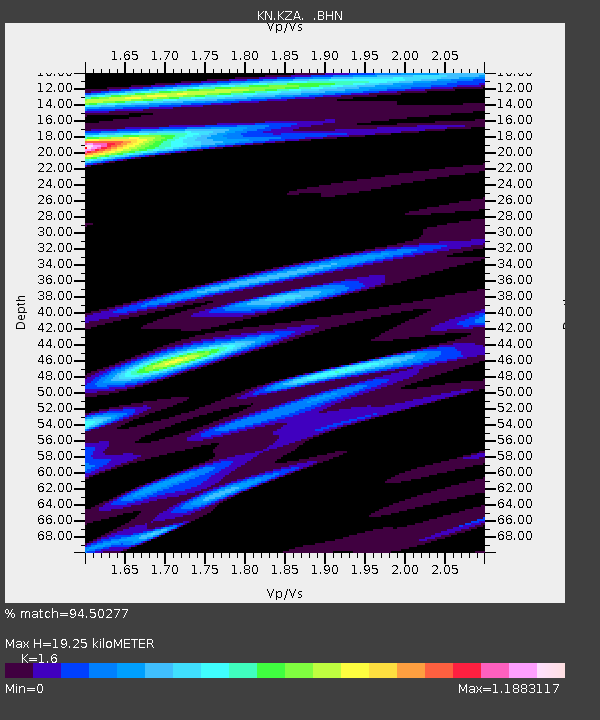
| Estimated Moho Depth: |
19.25 km |
| Estimated Crust Vp/Vs: |
1.60 |
| Assumed Crust Vp: |
6.306 km/s |
| Estimated Crust Vs: |
3.941 km/s |
| Estimated Crust Poisson's Ratio: |
0.18 |
|
| Radial Match: |
94.50277 % |
| Radial Bump: |
367 |
| Transverse Match: |
91.43063 % |
| Transverse Bump: |
400 |
| SOD ConfigId: |
2422 |
| Insert Time: |
2010-03-08 20:38:59.171 +0000 |
| GWidth: |
2.5 |
| Max Bumps: |
400 |
| Tol: |
0.001 |
|
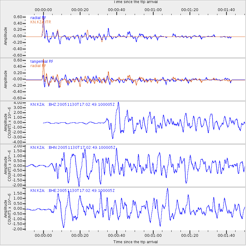
Signal To Noise
| Channel | StoN | STA | LTA |
| KN:KZA: :BHN:20051130T17:02:49.100005Z | 1.3654349 | 1.080419E-7 | 7.9126366E-8 |
| KN:KZA: :BHE:20051130T17:02:49.100005Z | 0.8463254 | 8.2275434E-8 | 9.7214894E-8 |
| KN:KZA: :BHZ:20051130T17:02:49.100005Z | 3.0910764 | 2.7091062E-7 | 8.764282E-8 |
| Arrivals |
| Ps | 1.9 SECOND |
| PpPs | 7.5 SECOND |
| PsPs/PpSs | 9.4 SECOND |


