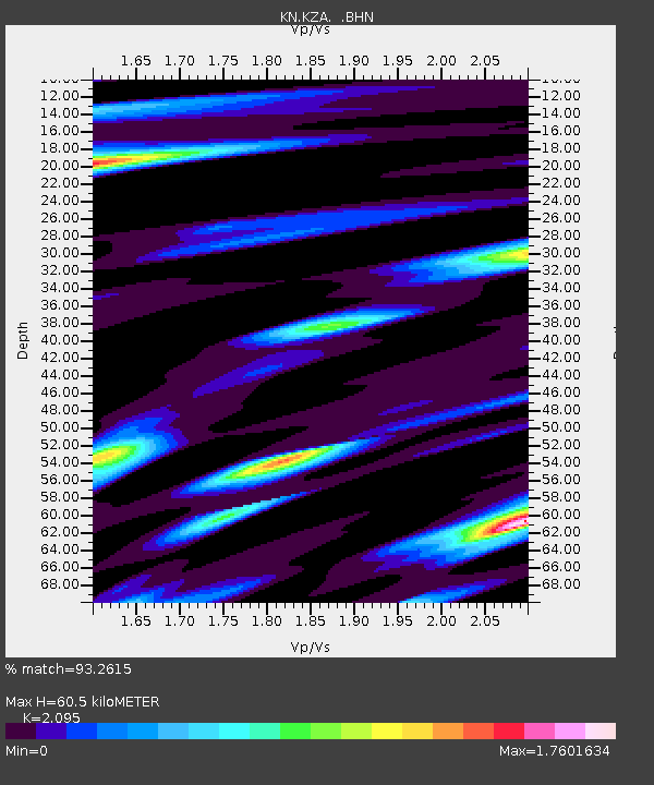
KZA KN.KZA - Earthquake Result Viewer
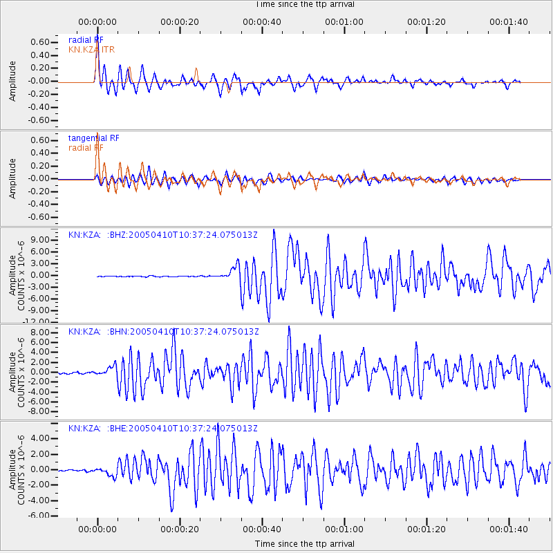
Earthquake location: Southern Sumatra, Indonesia
Earthquake latitude/longitude: -1.6/99.6
Earthquake time(UTC): 2005/04/10 (100) 10:29:11 GMT
Earthquake Depth: 19 km
Earthquake Magnitude: 6.4 MB, 6.7 MS, 6.7 MW, 6.6 MW
Earthquake Catalog/Contributor: WHDF/NEIC
Network: KN Kyrgyz Seismic Telemetry Network
Station: KZA KN.KZA
Lat/Lon: 42.08 N/75.25 E
Elevation: 3520 m
Distance: 48.8 deg
Az: 335.91 deg
Baz: 146.767 deg
Ray Param: 0.06910722
Estimated Moho Depth: 60.5 km
Estimated Crust Vp/Vs: 2.10
Assumed Crust Vp: 6.306 km/s
Estimated Crust Vs: 3.01 km/s
Estimated Crust Poisson's Ratio: 0.35
Radial Match: 93.2615 %
Radial Bump: 400
Transverse Match: 86.08532 %
Transverse Bump: 400
SOD ConfigId: 2459
Insert Time: 2010-03-08 20:39:51.526 +0000
GWidth: 2.5
Max Bumps: 400
Tol: 0.001

Signal To Noise

ChannelStoNSTALTA
KN:KZA: :BHN:20050410T10:37:24.075013Z6.55676849.3705455E-71.4291408E-7
KN:KZA: :BHE:20050410T10:37:24.075013Z6.0362795.103488E-78.454692E-8
KN:KZA: :BHZ:20050410T10:37:24.075013Z20.351561.8754423E-69.215226E-8
Arrivals
Ps11 SECOND
PpPs28 SECOND
PsPs/PpSs39 SECOND