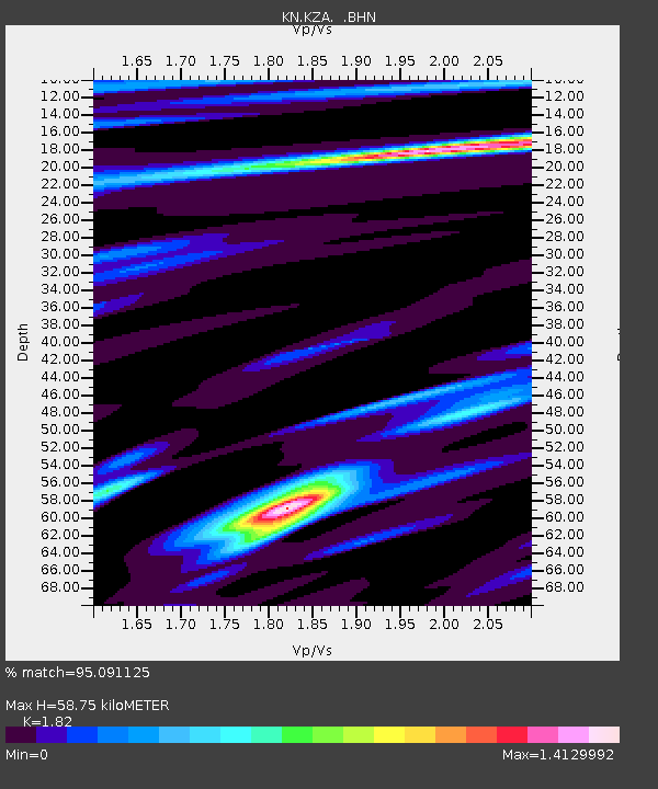
KZA KN.KZA - Earthquake Result Viewer
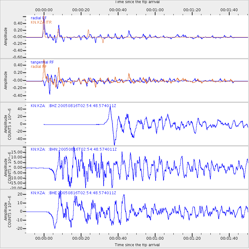
Earthquake location: Near East Coast Of Honshu, Japan
Earthquake latitude/longitude: 38.3/142.0
Earthquake time(UTC): 2005/08/16 (228) 02:46:28 GMT
Earthquake Depth: 36 km
Earthquake Magnitude: 6.5 MB, 6.8 MS, 7.2 MW, 7.1 MW
Earthquake Catalog/Contributor: WHDF/NEIC
Network: KN Kyrgyz Seismic Telemetry Network
Station: KZA KN.KZA
Lat/Lon: 42.08 N/75.25 E
Elevation: 3520 m
Distance: 50.0 deg
Az: 296.724 deg
Baz: 70.782 deg
Ray Param: 0.06827185
Estimated Moho Depth: 58.75 km
Estimated Crust Vp/Vs: 1.82
Assumed Crust Vp: 6.306 km/s
Estimated Crust Vs: 3.465 km/s
Estimated Crust Poisson's Ratio: 0.28
Radial Match: 95.091125 %
Radial Bump: 354
Transverse Match: 92.27943 %
Transverse Bump: 400
SOD ConfigId: 2475
Insert Time: 2010-03-08 20:40:03.197 +0000
GWidth: 2.5
Max Bumps: 400
Tol: 0.001

Signal To Noise

ChannelStoNSTALTA
KN:KZA: :BHN:20050816T02:54:48.574011Z19.8244231.0056727E-65.0728975E-8
KN:KZA: :BHE:20050816T02:54:48.574011Z36.698192.3937607E-66.5228306E-8
KN:KZA: :BHZ:20050816T02:54:48.574011Z61.5682455.8854343E-69.559205E-8
Arrivals
Ps8.1 SECOND
PpPs25 SECOND
PsPs/PpSs33 SECOND