You are here: Home > Network List > KN - Kyrgyz Seismic Telemetry Network Stations List
> Station KZA KN.KZA > Earthquake Result Viewer
KZA KN.KZA - Earthquake Result Viewer
| Earthquake location: |
Kuril Islands |
| Earthquake latitude/longitude: |
43.9/146.1 |
| Earthquake time(UTC): |
2005/09/21 (264) 02:25:08 GMT |
| Earthquake Depth: |
103 km |
| Earthquake Magnitude: |
6.0 MB, 6.1 MW, 6.0 MW |
| Earthquake Catalog/Contributor: |
WHDF/NEIC |
|
| Network: |
KN Kyrgyz Seismic Telemetry Network |
| Station: |
KZA KN.KZA |
| Lat/Lon: |
42.08 N/75.25 E |
| Elevation: |
3520 m |
|
| Distance: |
50.4 deg |
| Az: |
294.078 deg |
| Baz: |
62.452 deg |
| Ray Param: |
0.06774191 |
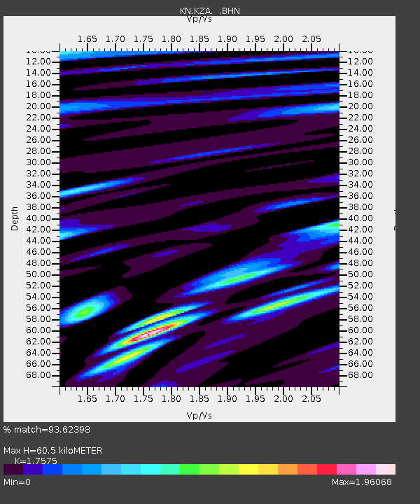
| Estimated Moho Depth: |
60.5 km |
| Estimated Crust Vp/Vs: |
1.76 |
| Assumed Crust Vp: |
6.306 km/s |
| Estimated Crust Vs: |
3.588 km/s |
| Estimated Crust Poisson's Ratio: |
0.26 |
|
| Radial Match: |
93.62398 % |
| Radial Bump: |
400 |
| Transverse Match: |
84.43822 % |
| Transverse Bump: |
400 |
| SOD ConfigId: |
2475 |
| Insert Time: |
2010-03-08 20:40:09.948 +0000 |
| GWidth: |
2.5 |
| Max Bumps: |
400 |
| Tol: |
0.001 |
|
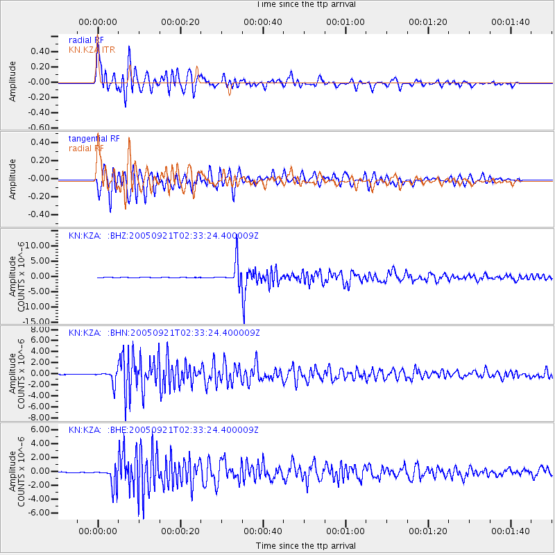
Signal To Noise
| Channel | StoN | STA | LTA |
| KN:KZA: :BHN:20050921T02:33:24.400009Z | 7.9825177 | 1.1647492E-6 | 1.459125E-7 |
| KN:KZA: :BHE:20050921T02:33:24.400009Z | 14.9234085 | 1.4654073E-6 | 9.8195216E-8 |
| KN:KZA: :BHZ:20050921T02:33:24.400009Z | 74.69528 | 3.8484295E-6 | 5.1521724E-8 |
| Arrivals |
| Ps | 7.7 SECOND |
| PpPs | 25 SECOND |
| PsPs/PpSs | 33 SECOND |


