You are here: Home > Network List > CN - Canadian National Seismograph Network Stations List
> Station INK INUVIK, NT > Earthquake Result Viewer
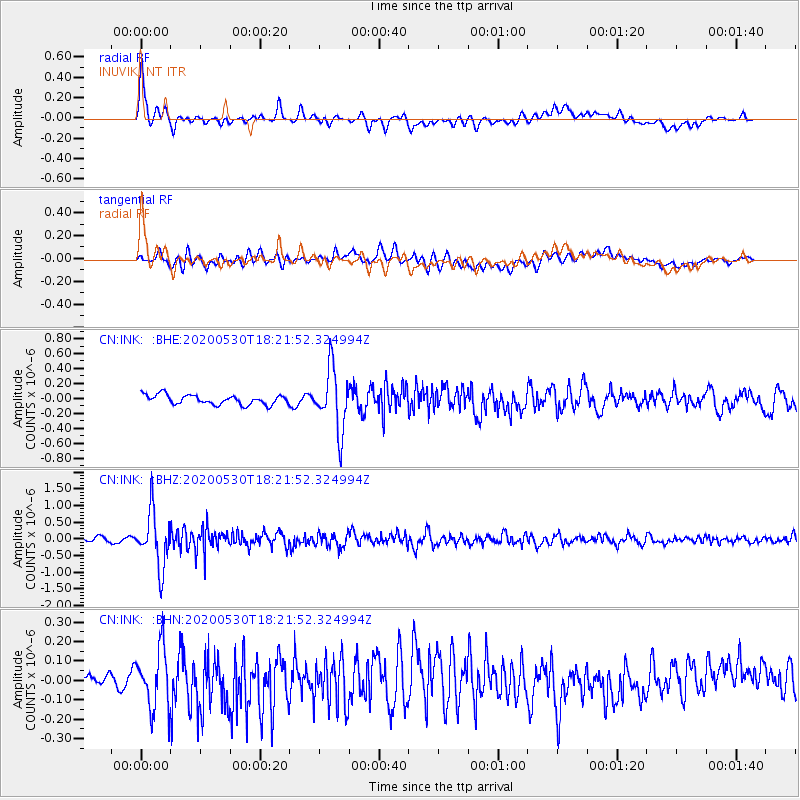
INK INUVIK, NT - Earthquake Result Viewer
*The percent match for this event was below the threshold and hence no stack was calculated.
| Earthquake location: |
Hokkaido, Japan Region |
| Earthquake latitude/longitude: |
42.4/143.9 |
| Earthquake time(UTC): |
2020/05/30 (151) 18:13:47 GMT |
| Earthquake Depth: |
94 km |
| Earthquake Magnitude: |
5.6 Mww |
| Earthquake Catalog/Contributor: |
NEIC PDE/us |
|
| Network: |
CN Canadian National Seismograph Network |
| Station: |
INK INUVIK, NT |
| Lat/Lon: |
68.31 N/133.53 W |
| Elevation: |
44 m |
|
| Distance: |
48.7 deg |
| Az: |
29.378 deg |
| Baz: |
282.34 deg |
| Ray Param: |
$rayparam |
*The percent match for this event was below the threshold and hence was not used in the summary stack. |
|
| Radial Match: |
78.94988 % |
| Radial Bump: |
400 |
| Transverse Match: |
60.993446 % |
| Transverse Bump: |
400 |
| SOD ConfigId: |
21166931 |
| Insert Time: |
2020-06-13 18:23:44.117 +0000 |
| GWidth: |
2.5 |
| Max Bumps: |
400 |
| Tol: |
0.001 |
|
Signal To Noise
| Channel | StoN | STA | LTA |
| CN:INK: :BHZ:20200530T18:21:52.324994Z | 14.870258 | 8.180505E-7 | 5.501253E-8 |
| CN:INK: :BHN:20200530T18:21:52.324994Z | 3.8825276 | 1.5307535E-7 | 3.9426723E-8 |
| CN:INK: :BHE:20200530T18:21:52.324994Z | 6.425036 | 4.0656386E-7 | 6.3278065E-8 |
| Arrivals |
| Ps | |
| PpPs | |
| PsPs/PpSs | |


