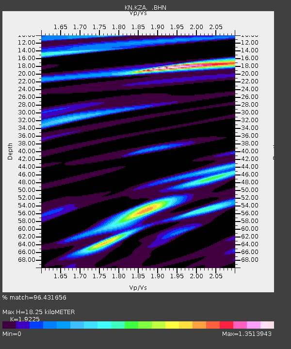
KZA KN.KZA - Earthquake Result Viewer
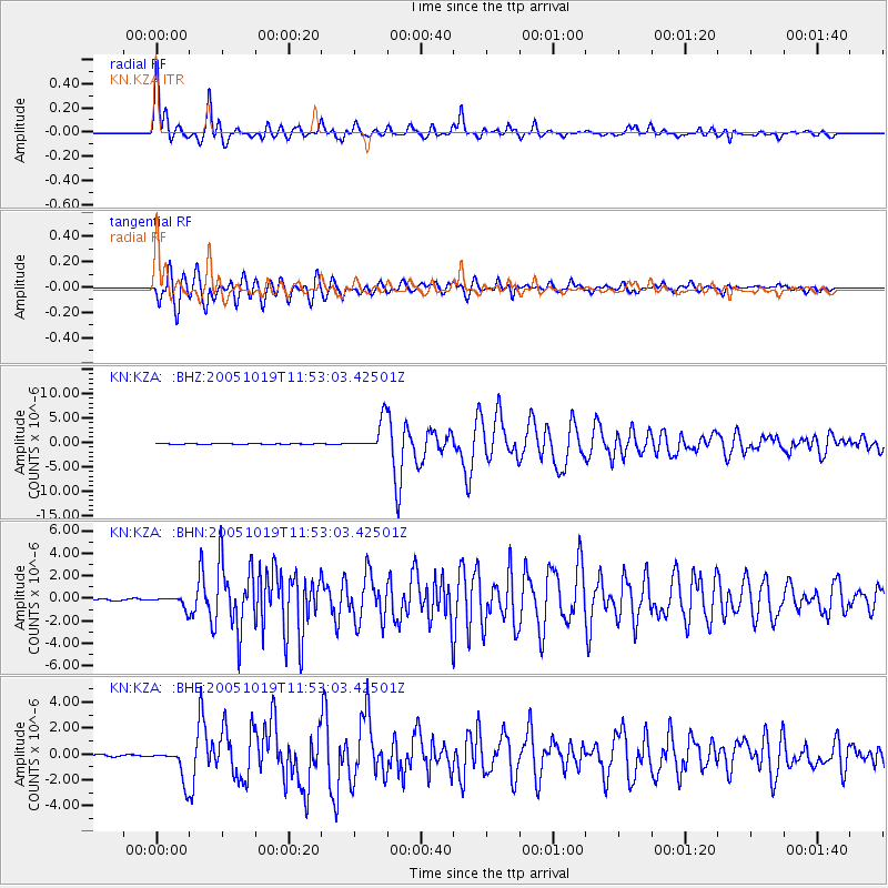
Earthquake location: Near East Coast Of Honshu, Japan
Earthquake latitude/longitude: 36.4/140.8
Earthquake time(UTC): 2005/10/19 (292) 11:44:42 GMT
Earthquake Depth: 32 km
Earthquake Magnitude: 6.2 MB, 6.5 MS, 6.4 MW, 6.3 MW
Earthquake Catalog/Contributor: WHDF/NEIC
Network: KN Kyrgyz Seismic Telemetry Network
Station: KZA KN.KZA
Lat/Lon: 42.08 N/75.25 E
Elevation: 3520 m
Distance: 50.0 deg
Az: 297.76 deg
Baz: 73.521 deg
Ray Param: 0.06828137
Estimated Moho Depth: 18.25 km
Estimated Crust Vp/Vs: 1.92
Assumed Crust Vp: 6.306 km/s
Estimated Crust Vs: 3.28 km/s
Estimated Crust Poisson's Ratio: 0.31
Radial Match: 96.431656 %
Radial Bump: 400
Transverse Match: 92.88945 %
Transverse Bump: 400
SOD ConfigId: 2475
Insert Time: 2010-03-08 20:40:11.682 +0000
GWidth: 2.5
Max Bumps: 400
Tol: 0.001

Signal To Noise

ChannelStoNSTALTA
KN:KZA: :BHN:20051019T11:53:03.42501Z6.47077275.052964E-77.808904E-8
KN:KZA: :BHE:20051019T11:53:03.42501Z18.8256441.2433991E-66.604816E-8
KN:KZA: :BHZ:20051019T11:53:03.42501Z58.911583.0777346E-65.224329E-8
Arrivals
Ps2.8 SECOND
PpPs8.0 SECOND
PsPs/PpSs11 SECOND