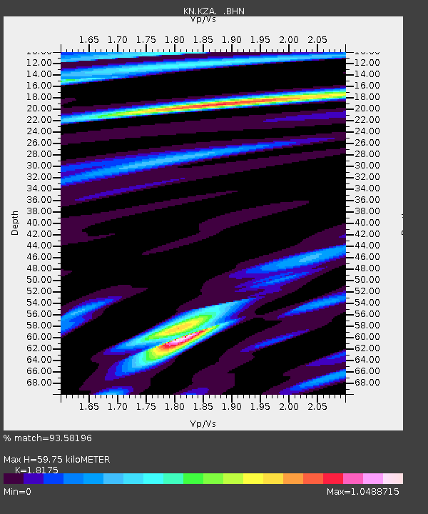
KZA KN.KZA - Earthquake Result Viewer

Earthquake location: Near West Coast Of Honshu, Japan
Earthquake latitude/longitude: 37.3/136.6
Earthquake time(UTC): 2007/03/25 (084) 00:41:57 GMT
Earthquake Depth: 8.0 km
Earthquake Magnitude: 6.1 MB, 6.8 MS, 6.7 MW, 6.6 MW
Earthquake Catalog/Contributor: WHDF/NEIC
Network: KN Kyrgyz Seismic Telemetry Network
Station: KZA KN.KZA
Lat/Lon: 42.08 N/75.25 E
Elevation: 3520 m
Distance: 46.5 deg
Az: 295.851 deg
Baz: 74.47 deg
Ray Param: 0.070584275
Estimated Moho Depth: 59.75 km
Estimated Crust Vp/Vs: 1.82
Assumed Crust Vp: 6.306 km/s
Estimated Crust Vs: 3.47 km/s
Estimated Crust Poisson's Ratio: 0.28
Radial Match: 93.58196 %
Radial Bump: 326
Transverse Match: 85.93638 %
Transverse Bump: 400
SOD ConfigId: 2564
Insert Time: 2010-03-08 20:40:26.846 +0000
GWidth: 2.5
Max Bumps: 400
Tol: 0.001

Signal To Noise

ChannelStoNSTALTA
KN:KZA: :BHN:20070325T00:49:54.873009Z3.29617433.6744348E-71.1147574E-7
KN:KZA: :BHE:20070325T00:49:54.873009Z7.1965269.840588E-71.3674082E-7
KN:KZA: :BHZ:20070325T00:49:54.873009Z36.042392.110666E-65.856066E-8
Arrivals
Ps8.2 SECOND
PpPs25 SECOND
PsPs/PpSs33 SECOND