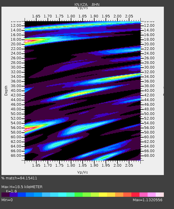
KZA KN.KZA - Earthquake Result Viewer
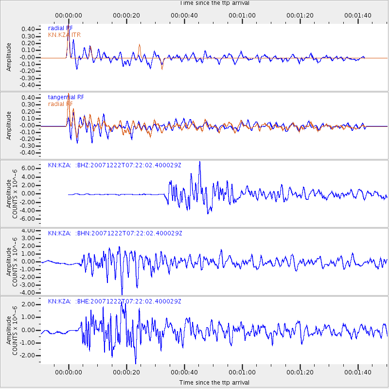
Earthquake location: Near North Coast Of Irian Jaya
Earthquake latitude/longitude: -2.4/139.1
Earthquake time(UTC): 2007/12/22 (356) 07:11:09 GMT
Earthquake Depth: 27 km
Earthquake Magnitude: 6.0 MB, 6.1 MS, 6.1 MW, 6.0 ME
Earthquake Catalog/Contributor: WHDF/NEIC
Network: KN Kyrgyz Seismic Telemetry Network
Station: KZA KN.KZA
Lat/Lon: 42.08 N/75.25 E
Elevation: 3520 m
Distance: 72.5 deg
Az: 315.546 deg
Baz: 109.966 deg
Ray Param: 0.05356847
Estimated Moho Depth: 18.5 km
Estimated Crust Vp/Vs: 1.60
Assumed Crust Vp: 6.306 km/s
Estimated Crust Vs: 3.941 km/s
Estimated Crust Poisson's Ratio: 0.18
Radial Match: 94.15411 %
Radial Bump: 400
Transverse Match: 87.46577 %
Transverse Bump: 400
SOD ConfigId: 2564
Insert Time: 2010-03-08 20:40:42.804 +0000
GWidth: 2.5
Max Bumps: 400
Tol: 0.001

Signal To Noise

ChannelStoNSTALTA
KN:KZA: :BHN:20071222T07:22:02.400029Z4.3606683.2382255E-77.4259844E-8
KN:KZA: :BHE:20071222T07:22:02.400029Z2.2805912.5673955E-71.1257589E-7
KN:KZA: :BHZ:20071222T07:22:02.400029Z11.07848557.77381E-77.017033E-8
Arrivals
Ps1.8 SECOND
PpPs7.3 SECOND
PsPs/PpSs9.2 SECOND