You are here: Home > Network List > IU - Global Seismograph Network (GSN - IRIS/USGS) Stations List
> Station RSSD Black Hills, South Dakota, USA > Earthquake Result Viewer
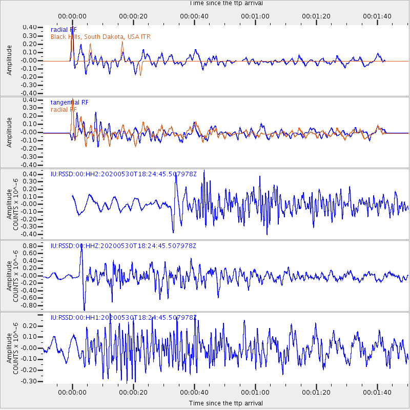
RSSD Black Hills, South Dakota, USA - Earthquake Result Viewer
*The percent match for this event was below the threshold and hence no stack was calculated.
| Earthquake location: |
Hokkaido, Japan Region |
| Earthquake latitude/longitude: |
42.4/143.9 |
| Earthquake time(UTC): |
2020/05/30 (151) 18:13:47 GMT |
| Earthquake Depth: |
94 km |
| Earthquake Magnitude: |
5.6 Mww |
| Earthquake Catalog/Contributor: |
NEIC PDE/us |
|
| Network: |
IU Global Seismograph Network (GSN - IRIS/USGS) |
| Station: |
RSSD Black Hills, South Dakota, USA |
| Lat/Lon: |
44.12 N/104.04 W |
| Elevation: |
2090 m |
|
| Distance: |
74.5 deg |
| Az: |
43.843 deg |
| Baz: |
314.595 deg |
| Ray Param: |
$rayparam |
*The percent match for this event was below the threshold and hence was not used in the summary stack. |
|
| Radial Match: |
66.6105 % |
| Radial Bump: |
400 |
| Transverse Match: |
64.08521 % |
| Transverse Bump: |
400 |
| SOD ConfigId: |
21166931 |
| Insert Time: |
2020-06-13 18:28:08.638 +0000 |
| GWidth: |
2.5 |
| Max Bumps: |
400 |
| Tol: |
0.001 |
|
Signal To Noise
| Channel | StoN | STA | LTA |
| IU:RSSD:00:HHZ:20200530T18:24:45.507978Z | 7.5959244 | 3.7623604E-7 | 4.9531305E-8 |
| IU:RSSD:00:HH1:20200530T18:24:45.507978Z | 1.7939969 | 9.074812E-8 | 5.058432E-8 |
| IU:RSSD:00:HH2:20200530T18:24:45.507978Z | 2.5347223 | 1.6918251E-7 | 6.6745976E-8 |
| Arrivals |
| Ps | |
| PpPs | |
| PsPs/PpSs | |


