You are here: Home > Network List > KN - Kyrgyz Seismic Telemetry Network Stations List
> Station KZA KN.KZA > Earthquake Result Viewer
KZA KN.KZA - Earthquake Result Viewer
| Earthquake location: |
Banda Sea |
| Earthquake latitude/longitude: |
-6.1/130.4 |
| Earthquake time(UTC): |
2009/10/24 (297) 14:40:43 GMT |
| Earthquake Depth: |
130 km |
| Earthquake Magnitude: |
6.7 MB, 6.9 MW, 6.9 MW |
| Earthquake Catalog/Contributor: |
WHDF/NEIC |
|
| Network: |
KN Kyrgyz Seismic Telemetry Network |
| Station: |
KZA KN.KZA |
| Lat/Lon: |
42.08 N/75.25 E |
| Elevation: |
3520 m |
|
| Distance: |
69.4 deg |
| Az: |
319.255 deg |
| Baz: |
119.336 deg |
| Ray Param: |
0.05534482 |
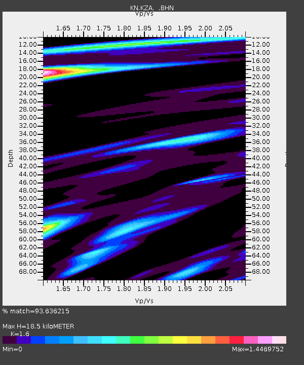
| Estimated Moho Depth: |
18.5 km |
| Estimated Crust Vp/Vs: |
1.60 |
| Assumed Crust Vp: |
6.306 km/s |
| Estimated Crust Vs: |
3.941 km/s |
| Estimated Crust Poisson's Ratio: |
0.18 |
|
| Radial Match: |
93.636215 % |
| Radial Bump: |
327 |
| Transverse Match: |
91.04717 % |
| Transverse Bump: |
400 |
| SOD ConfigId: |
2622 |
| Insert Time: |
2010-03-08 20:41:54.965 +0000 |
| GWidth: |
2.5 |
| Max Bumps: |
400 |
| Tol: |
0.001 |
|

Signal To Noise
| Channel | StoN | STA | LTA |
| KN:KZA: :BHN:20091024T14:51:06.524016Z | 66.25742 | 5.2681376E-6 | 7.9510144E-8 |
| KN:KZA: :BHE:20091024T14:51:06.524016Z | 4.9102397 | 1.0733384E-6 | 2.1859185E-7 |
| KN:KZA: :BHZ:20091024T14:51:06.524016Z | 21.391548 | 1.6239321E-6 | 7.5914656E-8 |
| Arrivals |
| Ps | 1.8 SECOND |
| PpPs | 7.3 SECOND |
| PsPs/PpSs | 9.2 SECOND |


