You are here: Home > Network List > TA - USArray Transportable Network (new EarthScope stations) Stations List
> Station D25K Kavik River, AK, USA > Earthquake Result Viewer
D25K Kavik River, AK, USA - Earthquake Result Viewer
| Earthquake location: |
Hokkaido, Japan Region |
| Earthquake latitude/longitude: |
42.4/143.9 |
| Earthquake time(UTC): |
2020/05/30 (151) 18:13:47 GMT |
| Earthquake Depth: |
94 km |
| Earthquake Magnitude: |
5.6 Mww |
| Earthquake Catalog/Contributor: |
NEIC PDE/us |
|
| Network: |
TA USArray Transportable Network (new EarthScope stations) |
| Station: |
D25K Kavik River, AK, USA |
| Lat/Lon: |
69.32 N/146.38 W |
| Elevation: |
770 m |
|
| Distance: |
44.0 deg |
| Az: |
28.669 deg |
| Baz: |
269.873 deg |
| Ray Param: |
0.07191197 |
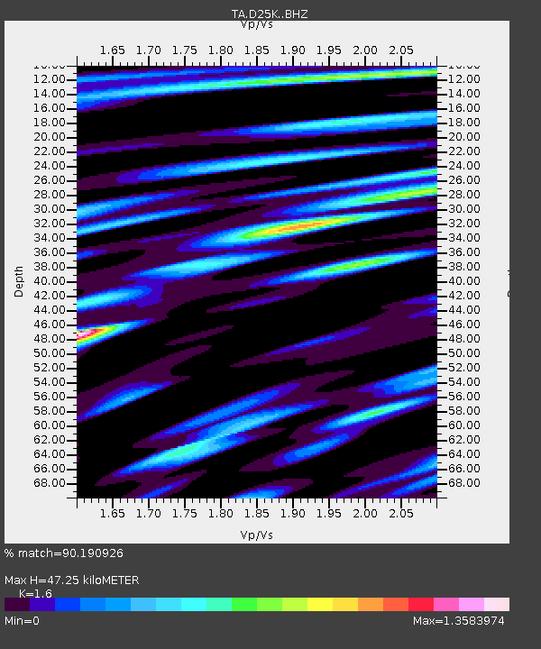
| Estimated Moho Depth: |
47.25 km |
| Estimated Crust Vp/Vs: |
1.60 |
| Assumed Crust Vp: |
6.378 km/s |
| Estimated Crust Vs: |
3.986 km/s |
| Estimated Crust Poisson's Ratio: |
0.18 |
|
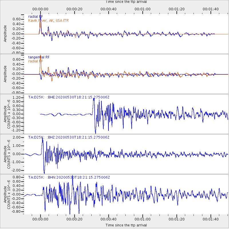
| Radial Match: |
90.190926 % |
| Radial Bump: |
400 |
| Transverse Match: |
86.165306 % |
| Transverse Bump: |
400 |
| SOD ConfigId: |
21166931 |
| Insert Time: |
2020-06-13 18:37:31.259 +0000 |
| GWidth: |
2.5 |
| Max Bumps: |
400 |
| Tol: |
0.001 |
|
Signal To Noise
| Channel | StoN | STA | LTA |
| TA:D25K: :BHZ:20200530T18:21:15.275006Z | 20.201853 | 1.0962541E-6 | 5.4265026E-8 |
| TA:D25K: :BHN:20200530T18:21:15.275006Z | 8.899398 | 2.3400662E-7 | 2.6294657E-8 |
| TA:D25K: :BHE:20200530T18:21:15.275006Z | 16.369654 | 6.9027493E-7 | 4.216796E-8 |
| Arrivals |
| Ps | 4.8 SECOND |
| PpPs | 18 SECOND |
| PsPs/PpSs | 23 SECOND |


