You are here: Home > Network List > TA - USArray Transportable Network (new EarthScope stations) Stations List
> Station F31M Tsiigehtchic, NWT, CAN > Earthquake Result Viewer
F31M Tsiigehtchic, NWT, CAN - Earthquake Result Viewer
| Earthquake location: |
Hokkaido, Japan Region |
| Earthquake latitude/longitude: |
42.4/143.9 |
| Earthquake time(UTC): |
2020/05/30 (151) 18:13:47 GMT |
| Earthquake Depth: |
94 km |
| Earthquake Magnitude: |
5.6 Mww |
| Earthquake Catalog/Contributor: |
NEIC PDE/us |
|
| Network: |
TA USArray Transportable Network (new EarthScope stations) |
| Station: |
F31M Tsiigehtchic, NWT, CAN |
| Lat/Lon: |
67.44 N/133.74 W |
| Elevation: |
56 m |
|
| Distance: |
48.8 deg |
| Az: |
30.53 deg |
| Baz: |
282.899 deg |
| Ray Param: |
0.068803154 |
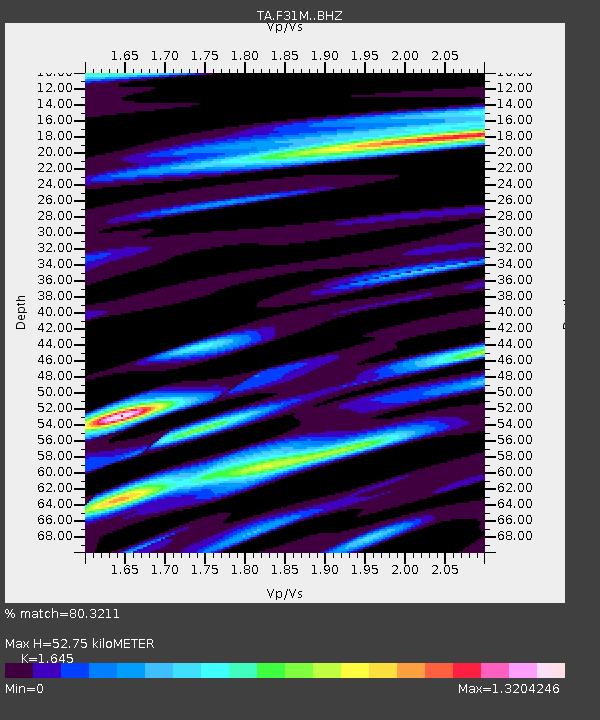
| Estimated Moho Depth: |
52.75 km |
| Estimated Crust Vp/Vs: |
1.64 |
| Assumed Crust Vp: |
6.171 km/s |
| Estimated Crust Vs: |
3.752 km/s |
| Estimated Crust Poisson's Ratio: |
0.21 |
|
| Radial Match: |
80.3211 % |
| Radial Bump: |
400 |
| Transverse Match: |
73.722244 % |
| Transverse Bump: |
400 |
| SOD ConfigId: |
21166931 |
| Insert Time: |
2020-06-13 18:38:10.849 +0000 |
| GWidth: |
2.5 |
| Max Bumps: |
400 |
| Tol: |
0.001 |
|
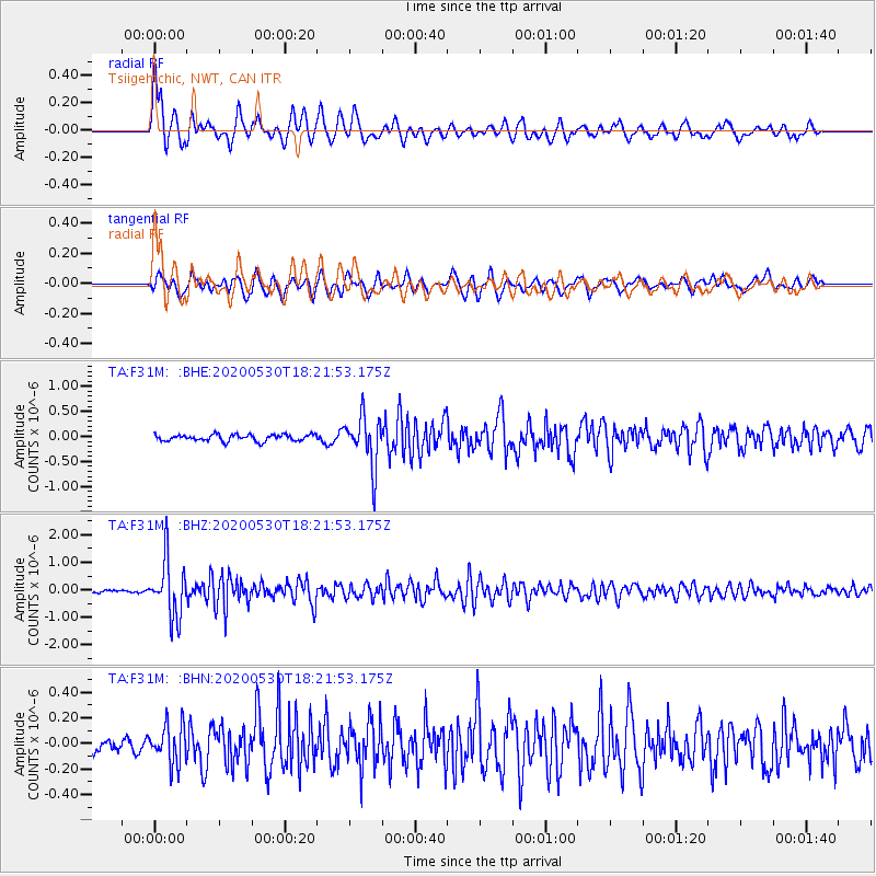
Signal To Noise
| Channel | StoN | STA | LTA |
| TA:F31M: :BHZ:20200530T18:21:53.175Z | 17.1661 | 1.0168483E-6 | 5.9235834E-8 |
| TA:F31M: :BHN:20200530T18:21:53.175Z | 2.3550372 | 1.4899808E-7 | 6.326783E-8 |
| TA:F31M: :BHE:20200530T18:21:53.175Z | 7.6806827 | 4.9767294E-7 | 6.479541E-8 |
| Arrivals |
| Ps | 5.8 SECOND |
| PpPs | 21 SECOND |
| PsPs/PpSs | 27 SECOND |


