You are here: Home > Network List > KN - Kyrgyz Seismic Telemetry Network Stations List
> Station KZA KN.KZA > Earthquake Result Viewer
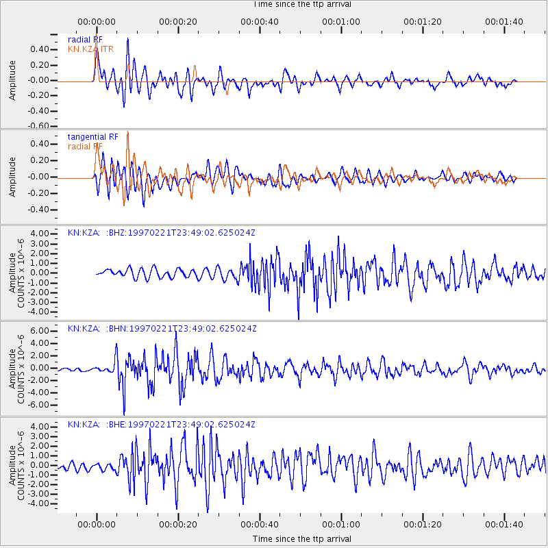
KZA KN.KZA - Earthquake Result Viewer
*The percent match for this event was below the threshold and hence no stack was calculated.
| Earthquake location: |
East Of Kuril Islands |
| Earthquake latitude/longitude: |
43.8/149.2 |
| Earthquake time(UTC): |
1997/02/21 (052) 23:40:24 GMT |
| Earthquake Depth: |
33 km |
| Earthquake Magnitude: |
6.1 MB, 5.6 MS, 6.1 UNKNOWN, 6.1 MW |
| Earthquake Catalog/Contributor: |
WHDF/NEIC |
|
| Network: |
KN Kyrgyz Seismic Telemetry Network |
| Station: |
KZA KN.KZA |
| Lat/Lon: |
42.08 N/75.25 E |
| Elevation: |
3520 m |
|
| Distance: |
52.4 deg |
| Az: |
295.48 deg |
| Baz: |
61.353 deg |
| Ray Param: |
$rayparam |
*The percent match for this event was below the threshold and hence was not used in the summary stack. |
|
| Radial Match: |
85.89415 % |
| Radial Bump: |
400 |
| Transverse Match: |
80.12831 % |
| Transverse Bump: |
400 |
| SOD ConfigId: |
4480 |
| Insert Time: |
2010-03-08 20:42:59.936 +0000 |
| GWidth: |
2.5 |
| Max Bumps: |
400 |
| Tol: |
0.001 |
|
Signal To Noise
| Channel | StoN | STA | LTA |
| KN:KZA: :BHN:19970221T23:49:02.625024Z | 3.7784536 | 1.011499E-6 | 2.677018E-7 |
| KN:KZA: :BHE:19970221T23:49:02.625024Z | 0.9430332 | 3.1112071E-7 | 3.2991488E-7 |
| KN:KZA: :BHZ:19970221T23:49:02.625024Z | 1.4641492 | 6.0465715E-7 | 4.1297508E-7 |
| Arrivals |
| Ps | |
| PpPs | |
| PsPs/PpSs | |


