You are here: Home > Network List > AG - Arkansas Seismic Network Stations List
> Station HHAR Hobbs,AR > Earthquake Result Viewer
HHAR Hobbs,AR - Earthquake Result Viewer
| Earthquake location: |
Southern Peru |
| Earthquake latitude/longitude: |
-15.3/-70.7 |
| Earthquake time(UTC): |
2020/05/31 (152) 05:09:35 GMT |
| Earthquake Depth: |
153 km |
| Earthquake Magnitude: |
6.0 mww |
| Earthquake Catalog/Contributor: |
NEIC PDE/us |
|
| Network: |
AG Arkansas Seismic Network |
| Station: |
HHAR Hobbs,AR |
| Lat/Lon: |
36.28 N/93.94 W |
| Elevation: |
421 m |
|
| Distance: |
55.8 deg |
| Az: |
337.29 deg |
| Baz: |
152.539 deg |
| Ray Param: |
0.06406094 |
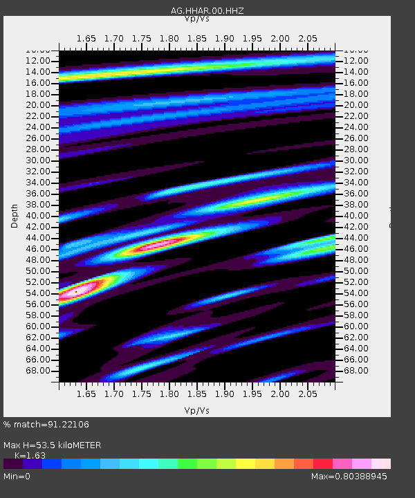
| Estimated Moho Depth: |
53.5 km |
| Estimated Crust Vp/Vs: |
1.63 |
| Assumed Crust Vp: |
6.53 km/s |
| Estimated Crust Vs: |
4.006 km/s |
| Estimated Crust Poisson's Ratio: |
0.20 |
|
| Radial Match: |
91.22106 % |
| Radial Bump: |
387 |
| Transverse Match: |
81.78759 % |
| Transverse Bump: |
308 |
| SOD ConfigId: |
21166931 |
| Insert Time: |
2020-06-14 05:10:49.053 +0000 |
| GWidth: |
2.5 |
| Max Bumps: |
400 |
| Tol: |
0.001 |
|

Signal To Noise
| Channel | StoN | STA | LTA |
| AG:HHAR:00:HHZ:20200531T05:18:26.064994Z | 33.753777 | 2.3051912E-6 | 6.829432E-8 |
| AG:HHAR:00:HHN:20200531T05:18:26.064994Z | 19.76025 | 7.5465545E-7 | 3.819058E-8 |
| AG:HHAR:00:HHE:20200531T05:18:26.064994Z | 10.393827 | 6.8565566E-7 | 6.596758E-8 |
| Arrivals |
| Ps | 5.5 SECOND |
| PpPs | 20 SECOND |
| PsPs/PpSs | 26 SECOND |


