You are here: Home > Network List > IU - Global Seismograph Network (GSN - IRIS/USGS) Stations List
> Station RSSD Black Hills, South Dakota, USA > Earthquake Result Viewer
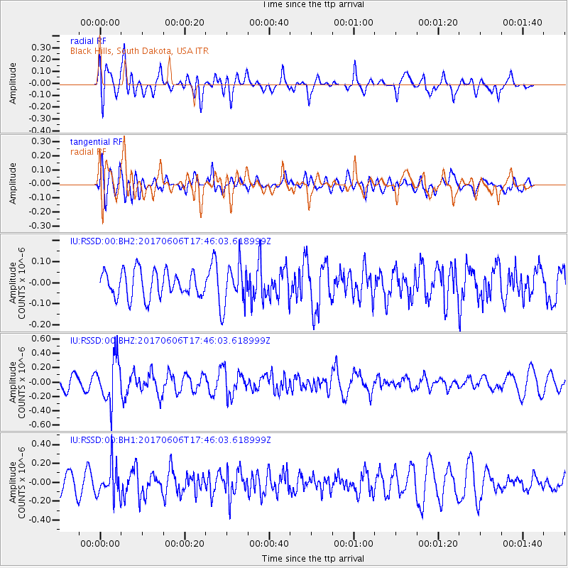
RSSD Black Hills, South Dakota, USA - Earthquake Result Viewer
*The percent match for this event was below the threshold and hence no stack was calculated.
| Earthquake location: |
Northern Chile |
| Earthquake latitude/longitude: |
-22.9/-68.6 |
| Earthquake time(UTC): |
2017/06/06 (157) 17:35:08 GMT |
| Earthquake Depth: |
97 km |
| Earthquake Magnitude: |
5.3 Mww |
| Earthquake Catalog/Contributor: |
NEIC PDE/us |
|
| Network: |
IU Global Seismograph Network (GSN - IRIS/USGS) |
| Station: |
RSSD Black Hills, South Dakota, USA |
| Lat/Lon: |
44.12 N/104.04 W |
| Elevation: |
2090 m |
|
| Distance: |
74.2 deg |
| Az: |
334.289 deg |
| Baz: |
146.26 deg |
| Ray Param: |
$rayparam |
*The percent match for this event was below the threshold and hence was not used in the summary stack. |
|
| Radial Match: |
50.73159 % |
| Radial Bump: |
400 |
| Transverse Match: |
52.92796 % |
| Transverse Bump: |
400 |
| SOD ConfigId: |
2140511 |
| Insert Time: |
2017-06-20 09:28:51.979 +0000 |
| GWidth: |
2.5 |
| Max Bumps: |
400 |
| Tol: |
0.001 |
|
Signal To Noise
| Channel | StoN | STA | LTA |
| IU:RSSD:00:BHZ:20170606T17:46:03.618999Z | 3.0714107 | 3.057241E-7 | 9.953865E-8 |
| IU:RSSD:00:BH1:20170606T17:46:03.618999Z | 2.0080042 | 1.6530541E-7 | 8.232324E-8 |
| IU:RSSD:00:BH2:20170606T17:46:03.618999Z | 1.4767174 | 9.071674E-8 | 6.143135E-8 |
| Arrivals |
| Ps | |
| PpPs | |
| PsPs/PpSs | |


