You are here: Home > Network List > KN - Kyrgyz Seismic Telemetry Network Stations List
> Station KZA KN.KZA > Earthquake Result Viewer
KZA KN.KZA - Earthquake Result Viewer
*The percent match for this event was below the threshold and hence no stack was calculated.
| Earthquake location: |
Kuril Islands |
| Earthquake latitude/longitude: |
43.1/146.5 |
| Earthquake time(UTC): |
2008/03/13 (073) 08:41:07 GMT |
| Earthquake Depth: |
53 km |
| Earthquake Magnitude: |
5.6 MB, 5.4 MW, 5.3 MW |
| Earthquake Catalog/Contributor: |
WHDF/NEIC |
|
| Network: |
KN Kyrgyz Seismic Telemetry Network |
| Station: |
KZA KN.KZA |
| Lat/Lon: |
42.08 N/75.25 E |
| Elevation: |
3520 m |
|
| Distance: |
51.0 deg |
| Az: |
294.862 deg |
| Baz: |
63.274 deg |
| Ray Param: |
$rayparam |
*The percent match for this event was below the threshold and hence was not used in the summary stack. |
|
| Radial Match: |
82.51883 % |
| Radial Bump: |
400 |
| Transverse Match: |
69.13376 % |
| Transverse Bump: |
400 |
| SOD ConfigId: |
2504 |
| Insert Time: |
2010-03-08 20:43:46.078 +0000 |
| GWidth: |
2.5 |
| Max Bumps: |
400 |
| Tol: |
0.001 |
|
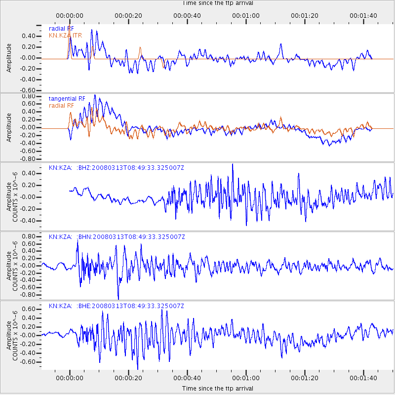
Signal To Noise
| Channel | StoN | STA | LTA |
| KN:KZA: :BHN:20080313T08:49:33.325007Z | 4.602364 | 2.5269847E-7 | 5.4906238E-8 |
| KN:KZA: :BHE:20080313T08:49:33.325007Z | 1.3971324 | 1.5667266E-7 | 1.12138736E-7 |
| KN:KZA: :BHZ:20080313T08:49:33.325007Z | 1.279229 | 1.0074502E-7 | 7.8754475E-8 |
| Arrivals |
| Ps | |
| PpPs | |
| PsPs/PpSs | |


