You are here: Home > Network List > GS - US Geological Survey Networks Stations List
> Station OK051 E0350 and S34600 Roads, Ralston, OK > Earthquake Result Viewer
OK051 E0350 and S34600 Roads, Ralston, OK - Earthquake Result Viewer
| Earthquake location: |
Southern Peru |
| Earthquake latitude/longitude: |
-15.3/-70.7 |
| Earthquake time(UTC): |
2020/05/31 (152) 05:09:35 GMT |
| Earthquake Depth: |
153 km |
| Earthquake Magnitude: |
6.0 mww |
| Earthquake Catalog/Contributor: |
NEIC PDE/us |
|
| Network: |
GS US Geological Survey Networks |
| Station: |
OK051 E0350 and S34600 Roads, Ralston, OK |
| Lat/Lon: |
36.51 N/96.84 W |
| Elevation: |
263 m |
|
| Distance: |
57.1 deg |
| Az: |
334.967 deg |
| Baz: |
149.544 deg |
| Ray Param: |
0.06321412 |
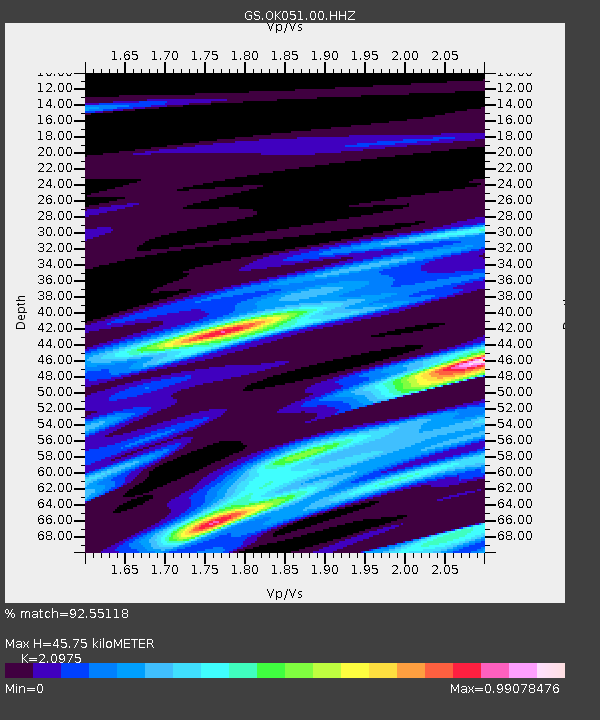
| Estimated Moho Depth: |
45.75 km |
| Estimated Crust Vp/Vs: |
2.10 |
| Assumed Crust Vp: |
6.483 km/s |
| Estimated Crust Vs: |
3.091 km/s |
| Estimated Crust Poisson's Ratio: |
0.35 |
|
| Radial Match: |
92.55118 % |
| Radial Bump: |
400 |
| Transverse Match: |
80.46171 % |
| Transverse Bump: |
400 |
| SOD ConfigId: |
21166931 |
| Insert Time: |
2020-06-14 05:20:28.122 +0000 |
| GWidth: |
2.5 |
| Max Bumps: |
400 |
| Tol: |
0.001 |
|
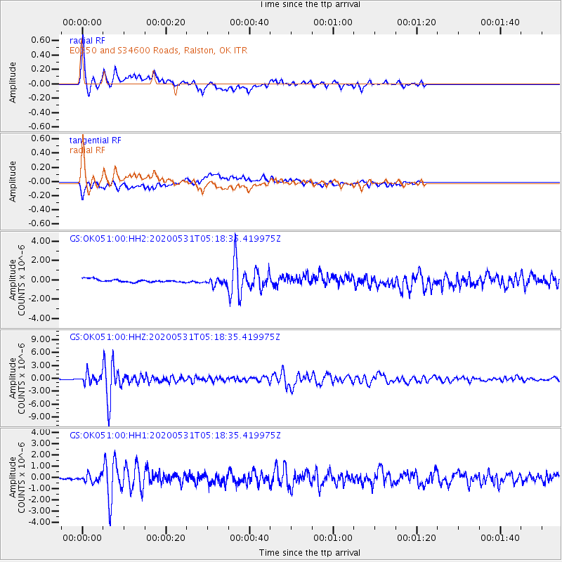
Signal To Noise
| Channel | StoN | STA | LTA |
| GS:OK051:00:HHZ:20200531T05:18:35.419975Z | 9.746858 | 1.0769403E-6 | 1.10491015E-7 |
| GS:OK051:00:HH1:20200531T05:18:35.419975Z | 2.266066 | 3.099532E-7 | 1.367803E-7 |
| GS:OK051:00:HH2:20200531T05:18:35.419975Z | 2.3647914 | 3.4929116E-7 | 1.4770485E-7 |
| Arrivals |
| Ps | 8.1 SECOND |
| PpPs | 21 SECOND |
| PsPs/PpSs | 29 SECOND |


