You are here: Home > Network List > US - United States National Seismic Network Stations List
> Station MNTX Cornudas Mountains, Texas, USA > Earthquake Result Viewer
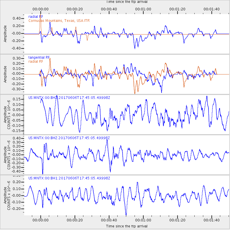
MNTX Cornudas Mountains, Texas, USA - Earthquake Result Viewer
*The percent match for this event was below the threshold and hence no stack was calculated.
| Earthquake location: |
Northern Chile |
| Earthquake latitude/longitude: |
-22.9/-68.6 |
| Earthquake time(UTC): |
2017/06/06 (157) 17:35:08 GMT |
| Earthquake Depth: |
97 km |
| Earthquake Magnitude: |
5.3 Mww |
| Earthquake Catalog/Contributor: |
NEIC PDE/us |
|
| Network: |
US United States National Seismic Network |
| Station: |
MNTX Cornudas Mountains, Texas, USA |
| Lat/Lon: |
31.70 N/105.38 W |
| Elevation: |
404 m |
|
| Distance: |
64.7 deg |
| Az: |
325.648 deg |
| Baz: |
142.382 deg |
| Ray Param: |
$rayparam |
*The percent match for this event was below the threshold and hence was not used in the summary stack. |
|
| Radial Match: |
50.506935 % |
| Radial Bump: |
400 |
| Transverse Match: |
39.02686 % |
| Transverse Bump: |
400 |
| SOD ConfigId: |
2140511 |
| Insert Time: |
2017-06-20 09:30:45.175 +0000 |
| GWidth: |
2.5 |
| Max Bumps: |
400 |
| Tol: |
0.001 |
|
Signal To Noise
| Channel | StoN | STA | LTA |
| US:MNTX:00:BHZ:20170606T17:45:05.49998Z | 2.410497 | 1.8578368E-7 | 7.707277E-8 |
| US:MNTX:00:BH1:20170606T17:45:05.49998Z | 0.7978115 | 8.8489216E-8 | 1.1091494E-7 |
| US:MNTX:00:BH2:20170606T17:45:05.49998Z | 0.70653147 | 5.9174134E-8 | 8.375301E-8 |
| Arrivals |
| Ps | |
| PpPs | |
| PsPs/PpSs | |


