You are here: Home > Network List > N4 - Central and EAstern US Network Stations List
> Station F33B 5 Mile Ranch, Herman, MN, USA > Earthquake Result Viewer
F33B 5 Mile Ranch, Herman, MN, USA - Earthquake Result Viewer
| Earthquake location: |
Southern Peru |
| Earthquake latitude/longitude: |
-15.3/-70.7 |
| Earthquake time(UTC): |
2020/05/31 (152) 05:09:35 GMT |
| Earthquake Depth: |
153 km |
| Earthquake Magnitude: |
6.0 mww |
| Earthquake Catalog/Contributor: |
NEIC PDE/us |
|
| Network: |
N4 Central and EAstern US Network |
| Station: |
F33B 5 Mile Ranch, Herman, MN, USA |
| Lat/Lon: |
45.84 N/96.29 W |
| Elevation: |
314 m |
|
| Distance: |
65.1 deg |
| Az: |
340.525 deg |
| Baz: |
152.596 deg |
| Ray Param: |
0.058045805 |
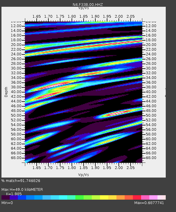
| Estimated Moho Depth: |
49.0 km |
| Estimated Crust Vp/Vs: |
1.99 |
| Assumed Crust Vp: |
6.552 km/s |
| Estimated Crust Vs: |
3.301 km/s |
| Estimated Crust Poisson's Ratio: |
0.33 |
|
| Radial Match: |
91.746826 % |
| Radial Bump: |
400 |
| Transverse Match: |
85.91877 % |
| Transverse Bump: |
400 |
| SOD ConfigId: |
21166931 |
| Insert Time: |
2020-06-14 05:23:12.779 +0000 |
| GWidth: |
2.5 |
| Max Bumps: |
400 |
| Tol: |
0.001 |
|

Signal To Noise
| Channel | StoN | STA | LTA |
| N4:F33B:00:HHZ:20200531T05:19:28.970023Z | 81.693405 | 4.8331726E-6 | 5.9162332E-8 |
| N4:F33B:00:HH1:20200531T05:19:28.970023Z | 54.361187 | 3.2913538E-6 | 6.054603E-8 |
| N4:F33B:00:HH2:20200531T05:19:28.970023Z | 47.975883 | 2.953037E-6 | 6.155253E-8 |
| Arrivals |
| Ps | 7.7 SECOND |
| PpPs | 21 SECOND |
| PsPs/PpSs | 29 SECOND |


