You are here: Home > Network List > N4 - Central and EAstern US Network Stations List
> Station N41A Harden Midland Farm, Stronghurst, IL, USA > Earthquake Result Viewer
N41A Harden Midland Farm, Stronghurst, IL, USA - Earthquake Result Viewer
| Earthquake location: |
Southern Peru |
| Earthquake latitude/longitude: |
-15.3/-70.7 |
| Earthquake time(UTC): |
2020/05/31 (152) 05:09:35 GMT |
| Earthquake Depth: |
153 km |
| Earthquake Magnitude: |
6.0 mww |
| Earthquake Catalog/Contributor: |
NEIC PDE/us |
|
| Network: |
N4 Central and EAstern US Network |
| Station: |
N41A Harden Midland Farm, Stronghurst, IL, USA |
| Lat/Lon: |
40.71 N/90.86 W |
| Elevation: |
226 m |
|
| Distance: |
58.8 deg |
| Az: |
342.129 deg |
| Baz: |
157.071 deg |
| Ray Param: |
0.06214887 |
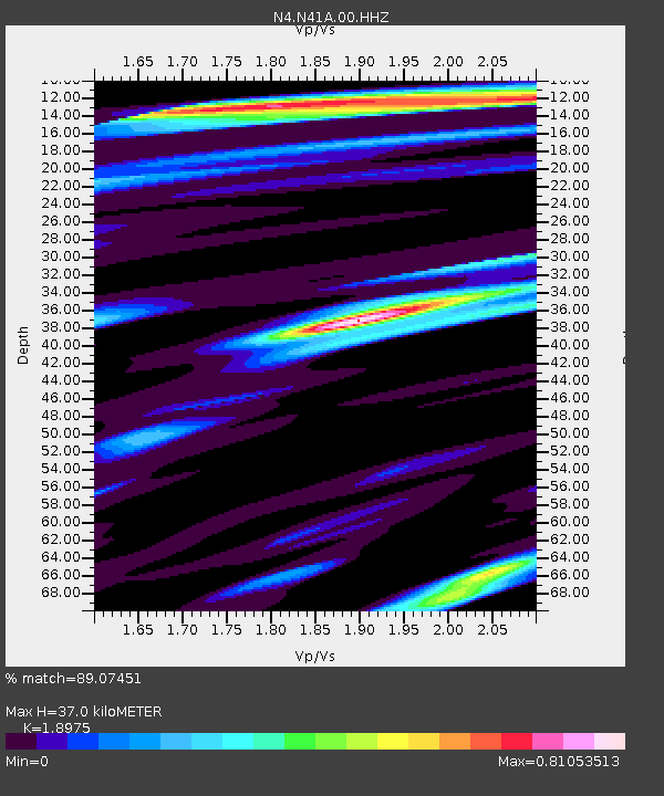
| Estimated Moho Depth: |
37.0 km |
| Estimated Crust Vp/Vs: |
1.90 |
| Assumed Crust Vp: |
6.498 km/s |
| Estimated Crust Vs: |
3.424 km/s |
| Estimated Crust Poisson's Ratio: |
0.31 |
|
| Radial Match: |
89.07451 % |
| Radial Bump: |
372 |
| Transverse Match: |
74.54198 % |
| Transverse Bump: |
400 |
| SOD ConfigId: |
21166931 |
| Insert Time: |
2020-06-14 05:24:13.446 +0000 |
| GWidth: |
2.5 |
| Max Bumps: |
400 |
| Tol: |
0.001 |
|

Signal To Noise
| Channel | StoN | STA | LTA |
| N4:N41A:00:HHZ:20200531T05:18:46.830009Z | 69.27805 | 6.1093388E-6 | 8.818577E-8 |
| N4:N41A:00:HH1:20200531T05:18:46.830009Z | 38.013447 | 2.5541515E-6 | 6.719073E-8 |
| N4:N41A:00:HH2:20200531T05:18:46.830009Z | 16.696844 | 1.3263773E-6 | 7.9438806E-8 |
| Arrivals |
| Ps | 5.3 SECOND |
| PpPs | 16 SECOND |
| PsPs/PpSs | 21 SECOND |


