You are here: Home > Network List > N4 - Central and EAstern US Network Stations List
> Station P53A Whipple, OH, USA > Earthquake Result Viewer
P53A Whipple, OH, USA - Earthquake Result Viewer
| Earthquake location: |
Southern Peru |
| Earthquake latitude/longitude: |
-15.3/-70.7 |
| Earthquake time(UTC): |
2020/05/31 (152) 05:09:35 GMT |
| Earthquake Depth: |
153 km |
| Earthquake Magnitude: |
6.0 mww |
| Earthquake Catalog/Contributor: |
NEIC PDE/us |
|
| Network: |
N4 Central and EAstern US Network |
| Station: |
P53A Whipple, OH, USA |
| Lat/Lon: |
39.49 N/81.39 W |
| Elevation: |
270 m |
|
| Distance: |
55.4 deg |
| Az: |
349.921 deg |
| Baz: |
167.393 deg |
| Ray Param: |
0.064336024 |
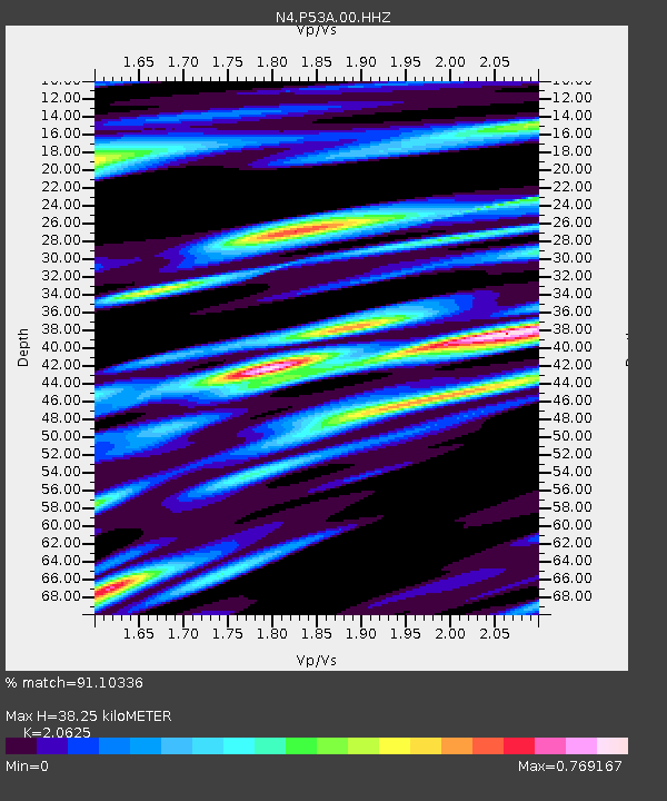
| Estimated Moho Depth: |
38.25 km |
| Estimated Crust Vp/Vs: |
2.06 |
| Assumed Crust Vp: |
6.207 km/s |
| Estimated Crust Vs: |
3.009 km/s |
| Estimated Crust Poisson's Ratio: |
0.35 |
|
| Radial Match: |
91.10336 % |
| Radial Bump: |
344 |
| Transverse Match: |
72.459564 % |
| Transverse Bump: |
400 |
| SOD ConfigId: |
21166931 |
| Insert Time: |
2020-06-14 05:24:38.899 +0000 |
| GWidth: |
2.5 |
| Max Bumps: |
400 |
| Tol: |
0.001 |
|

Signal To Noise
| Channel | StoN | STA | LTA |
| N4:P53A:00:HHZ:20200531T05:18:23.150016Z | 50.942715 | 5.183083E-6 | 1.0174337E-7 |
| N4:P53A:00:HH1:20200531T05:18:23.150016Z | 21.396803 | 1.6272909E-6 | 7.6053E-8 |
| N4:P53A:00:HH2:20200531T05:18:23.150016Z | 4.252871 | 4.4290235E-7 | 1.0414196E-7 |
| Arrivals |
| Ps | 6.8 SECOND |
| PpPs | 18 SECOND |
| PsPs/PpSs | 25 SECOND |


