You are here: Home > Network List > N4 - Central and EAstern US Network Stations List
> Station T59A Double 'B' Farms, VA, USA > Earthquake Result Viewer
T59A Double 'B' Farms, VA, USA - Earthquake Result Viewer
| Earthquake location: |
Southern Peru |
| Earthquake latitude/longitude: |
-15.3/-70.7 |
| Earthquake time(UTC): |
2020/05/31 (152) 05:09:35 GMT |
| Earthquake Depth: |
153 km |
| Earthquake Magnitude: |
6.0 mww |
| Earthquake Catalog/Contributor: |
NEIC PDE/us |
|
| Network: |
N4 Central and EAstern US Network |
| Station: |
T59A Double 'B' Farms, VA, USA |
| Lat/Lon: |
36.97 N/77.55 W |
| Elevation: |
63 m |
|
| Distance: |
52.4 deg |
| Az: |
353.031 deg |
| Baz: |
171.592 deg |
| Ray Param: |
0.06629328 |
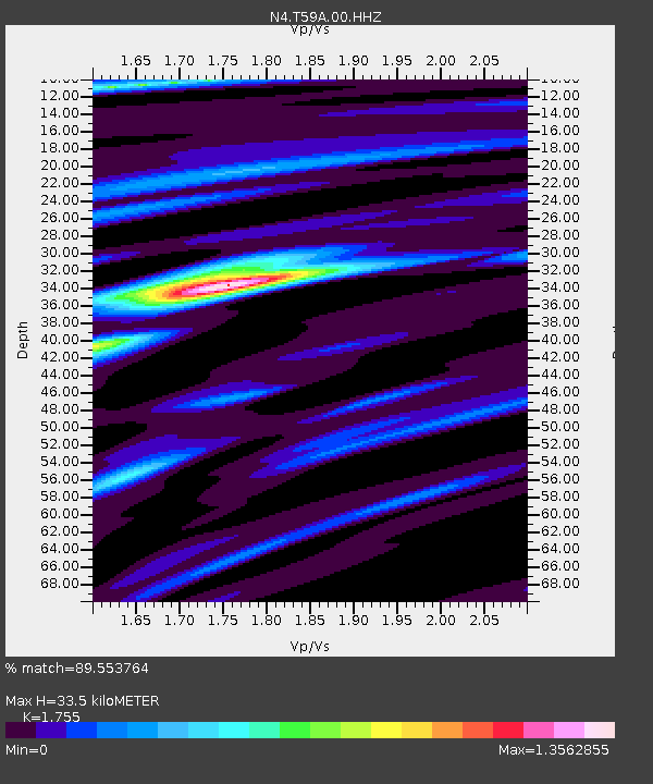
| Estimated Moho Depth: |
33.5 km |
| Estimated Crust Vp/Vs: |
1.75 |
| Assumed Crust Vp: |
6.565 km/s |
| Estimated Crust Vs: |
3.74 km/s |
| Estimated Crust Poisson's Ratio: |
0.26 |
|
| Radial Match: |
89.553764 % |
| Radial Bump: |
251 |
| Transverse Match: |
61.11943 % |
| Transverse Bump: |
400 |
| SOD ConfigId: |
21166931 |
| Insert Time: |
2020-06-14 05:25:21.200 +0000 |
| GWidth: |
2.5 |
| Max Bumps: |
400 |
| Tol: |
0.001 |
|

Signal To Noise
| Channel | StoN | STA | LTA |
| N4:T59A:00:HHZ:20200531T05:18:01.290Z | 24.269657 | 2.14635E-6 | 8.843759E-8 |
| N4:T59A:00:HH1:20200531T05:18:01.290Z | 21.482855 | 1.2453764E-6 | 5.7970713E-8 |
| N4:T59A:00:HH2:20200531T05:18:01.290Z | 3.9794009 | 1.9998379E-7 | 5.0254748E-8 |
| Arrivals |
| Ps | 4.1 SECOND |
| PpPs | 13 SECOND |
| PsPs/PpSs | 17 SECOND |


