You are here: Home > Network List > O2 - Oklahoma Consolidated Temporary Seismic Networks Stations List
> Station FW03 Mooreland, Oklahoma, USA > Earthquake Result Viewer
FW03 Mooreland, Oklahoma, USA - Earthquake Result Viewer
| Earthquake location: |
Southern Peru |
| Earthquake latitude/longitude: |
-15.3/-70.7 |
| Earthquake time(UTC): |
2020/05/31 (152) 05:09:35 GMT |
| Earthquake Depth: |
153 km |
| Earthquake Magnitude: |
6.0 mww |
| Earthquake Catalog/Contributor: |
NEIC PDE/us |
|
| Network: |
O2 Oklahoma Consolidated Temporary Seismic Networks |
| Station: |
FW03 Mooreland, Oklahoma, USA |
| Lat/Lon: |
36.53 N/99.17 W |
| Elevation: |
628 m |
|
| Distance: |
58.1 deg |
| Az: |
333.083 deg |
| Baz: |
147.151 deg |
| Ray Param: |
0.06256175 |
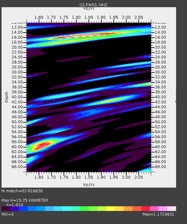
| Estimated Moho Depth: |
15.25 km |
| Estimated Crust Vp/Vs: |
1.82 |
| Assumed Crust Vp: |
6.426 km/s |
| Estimated Crust Vs: |
3.541 km/s |
| Estimated Crust Poisson's Ratio: |
0.28 |
|
| Radial Match: |
82.916626 % |
| Radial Bump: |
400 |
| Transverse Match: |
68.77811 % |
| Transverse Bump: |
400 |
| SOD ConfigId: |
21166931 |
| Insert Time: |
2020-06-14 05:28:03.866 +0000 |
| GWidth: |
2.5 |
| Max Bumps: |
400 |
| Tol: |
0.001 |
|

Signal To Noise
| Channel | StoN | STA | LTA |
| O2:FW03: :HHZ:20200531T05:18:42.429984Z | 10.438352 | 1.080034E-6 | 1.03467876E-7 |
| O2:FW03: :HHN:20200531T05:18:42.429984Z | 2.4946415 | 5.5439375E-7 | 2.2223382E-7 |
| O2:FW03: :HHE:20200531T05:18:42.429984Z | 2.558942 | 3.8741143E-7 | 1.5139517E-7 |
| Arrivals |
| Ps | 2.0 SECOND |
| PpPs | 6.4 SECOND |
| PsPs/PpSs | 8.4 SECOND |


