You are here: Home > Network List > O2 - Oklahoma Consolidated Temporary Seismic Networks Stations List
> Station KS13 South Haven SW Station, Kansas > Earthquake Result Viewer
KS13 South Haven SW Station, Kansas - Earthquake Result Viewer
| Earthquake location: |
Southern Peru |
| Earthquake latitude/longitude: |
-15.3/-70.7 |
| Earthquake time(UTC): |
2020/05/31 (152) 05:09:35 GMT |
| Earthquake Depth: |
153 km |
| Earthquake Magnitude: |
6.0 mww |
| Earthquake Catalog/Contributor: |
NEIC PDE/us |
|
| Network: |
O2 Oklahoma Consolidated Temporary Seismic Networks |
| Station: |
KS13 South Haven SW Station, Kansas |
| Lat/Lon: |
37.01 N/97.48 W |
| Elevation: |
340 m |
|
| Distance: |
57.8 deg |
| Az: |
334.748 deg |
| Baz: |
149.044 deg |
| Ray Param: |
0.06274873 |
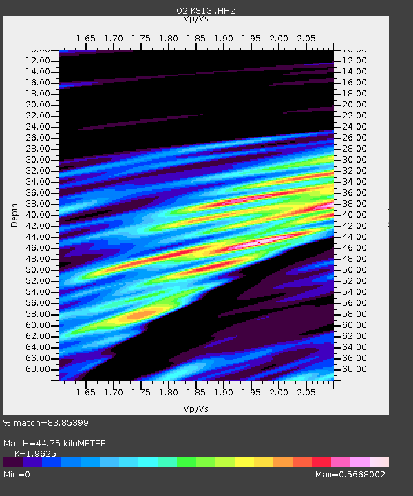
| Estimated Moho Depth: |
44.75 km |
| Estimated Crust Vp/Vs: |
1.96 |
| Assumed Crust Vp: |
6.483 km/s |
| Estimated Crust Vs: |
3.303 km/s |
| Estimated Crust Poisson's Ratio: |
0.32 |
|
| Radial Match: |
83.85399 % |
| Radial Bump: |
400 |
| Transverse Match: |
46.510082 % |
| Transverse Bump: |
400 |
| SOD ConfigId: |
21166931 |
| Insert Time: |
2020-06-14 05:28:17.515 +0000 |
| GWidth: |
2.5 |
| Max Bumps: |
400 |
| Tol: |
0.001 |
|

Signal To Noise
| Channel | StoN | STA | LTA |
| O2:KS13: :HHZ:20200531T05:18:40.299979Z | 6.2712755 | 1.3145658E-6 | 2.0961699E-7 |
| O2:KS13: :HHN:20200531T05:18:40.299979Z | 1.5353369 | 5.359067E-7 | 3.4904826E-7 |
| O2:KS13: :HHE:20200531T05:18:40.299979Z | 1.0487529 | 1.1197018E-6 | 1.0676507E-6 |
| Arrivals |
| Ps | 6.9 SECOND |
| PpPs | 20 SECOND |
| PsPs/PpSs | 27 SECOND |


