You are here: Home > Network List > O2 - Oklahoma Consolidated Temporary Seismic Networks Stations List
> Station PW13 Pawnee, Oklahoma, USA > Earthquake Result Viewer
PW13 Pawnee, Oklahoma, USA - Earthquake Result Viewer
| Earthquake location: |
Southern Peru |
| Earthquake latitude/longitude: |
-15.3/-70.7 |
| Earthquake time(UTC): |
2020/05/31 (152) 05:09:35 GMT |
| Earthquake Depth: |
153 km |
| Earthquake Magnitude: |
6.0 mww |
| Earthquake Catalog/Contributor: |
NEIC PDE/us |
|
| Network: |
O2 Oklahoma Consolidated Temporary Seismic Networks |
| Station: |
PW13 Pawnee, Oklahoma, USA |
| Lat/Lon: |
36.33 N/96.82 W |
| Elevation: |
290 m |
|
| Distance: |
57.0 deg |
| Az: |
334.875 deg |
| Baz: |
149.505 deg |
| Ray Param: |
0.06331563 |
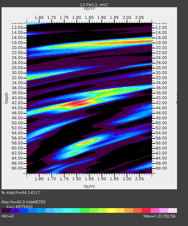
| Estimated Moho Depth: |
40.0 km |
| Estimated Crust Vp/Vs: |
1.86 |
| Assumed Crust Vp: |
6.483 km/s |
| Estimated Crust Vs: |
3.49 km/s |
| Estimated Crust Poisson's Ratio: |
0.30 |
|
| Radial Match: |
94.14117 % |
| Radial Bump: |
336 |
| Transverse Match: |
84.28326 % |
| Transverse Bump: |
400 |
| SOD ConfigId: |
21166931 |
| Insert Time: |
2020-06-14 05:28:31.089 +0000 |
| GWidth: |
2.5 |
| Max Bumps: |
400 |
| Tol: |
0.001 |
|

Signal To Noise
| Channel | StoN | STA | LTA |
| O2:PW13: :HHZ:20200531T05:18:34.304984Z | 16.201742 | 1.4096604E-6 | 8.700672E-8 |
| O2:PW13: :HHN:20200531T05:18:34.304984Z | 5.8956733 | 4.6679324E-7 | 7.9175564E-8 |
| O2:PW13: :HHE:20200531T05:18:34.304984Z | 2.808193 | 3.1426546E-7 | 1.1191022E-7 |
| Arrivals |
| Ps | 5.6 SECOND |
| PpPs | 17 SECOND |
| PsPs/PpSs | 22 SECOND |


