You are here: Home > Network List > O2 - Oklahoma Consolidated Temporary Seismic Networks Stations List
> Station TUTT Tuttle, Oklahoma, USA > Earthquake Result Viewer
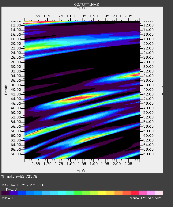
TUTT Tuttle, Oklahoma, USA - Earthquake Result Viewer
| Earthquake location: |
Southern Peru |
| Earthquake latitude/longitude: |
-15.3/-70.7 |
| Earthquake time(UTC): |
2020/05/31 (152) 05:09:35 GMT |
| Earthquake Depth: |
153 km |
| Earthquake Magnitude: |
6.0 mww |
| Earthquake Catalog/Contributor: |
NEIC PDE/us |
|
| Network: |
O2 Oklahoma Consolidated Temporary Seismic Networks |
| Station: |
TUTT Tuttle, Oklahoma, USA |
| Lat/Lon: |
35.24 N/97.76 W |
| Elevation: |
407 m |
|
| Distance: |
56.4 deg |
| Az: |
333.421 deg |
| Baz: |
148.161 deg |
| Ray Param: |
0.06365156 |
| Estimated Moho Depth: |
10.75 km |
| Estimated Crust Vp/Vs: |
1.60 |
| Assumed Crust Vp: |
6.426 km/s |
| Estimated Crust Vs: |
4.016 km/s |
| Estimated Crust Poisson's Ratio: |
0.18 |
|
| Radial Match: |
82.72576 % |
| Radial Bump: |
400 |
| Transverse Match: |
69.99686 % |
| Transverse Bump: |
400 |
| SOD ConfigId: |
21166931 |
| Insert Time: |
2020-06-14 05:29:10.547 +0000 |
| GWidth: |
2.5 |
| Max Bumps: |
400 |
| Tol: |
0.001 |
|

Signal To Noise
| Channel | StoN | STA | LTA |
| O2:TUTT: :HHZ:20200531T05:18:30.530021Z | 5.8332815 | 6.9019825E-7 | 1.18320756E-7 |
| O2:TUTT: :HHN:20200531T05:18:30.530021Z | 1.2638291 | 2.037806E-7 | 1.6124064E-7 |
| O2:TUTT: :HHE:20200531T05:18:30.530021Z | 1.7228171 | 2.2630849E-7 | 1.3135956E-7 |
| Arrivals |
| Ps | 1.1 SECOND |
| PpPs | 4.1 SECOND |
| PsPs/PpSs | 5.2 SECOND |


