You are here: Home > Network List > TD - TransAlta Monitoring Network Stations List
> Station TD013 Z > Earthquake Result Viewer
TD013 Z - Earthquake Result Viewer
| Earthquake location: |
Southern Peru |
| Earthquake latitude/longitude: |
-15.3/-70.7 |
| Earthquake time(UTC): |
2020/05/31 (152) 05:09:35 GMT |
| Earthquake Depth: |
153 km |
| Earthquake Magnitude: |
6.0 mww |
| Earthquake Catalog/Contributor: |
NEIC PDE/us |
|
| Network: |
TD TransAlta Monitoring Network |
| Station: |
TD013 Z |
| Lat/Lon: |
52.52 N/115.02 W |
| Elevation: |
975 m |
|
| Distance: |
77.6 deg |
| Az: |
334.06 deg |
| Baz: |
136.302 deg |
| Ray Param: |
0.049830027 |
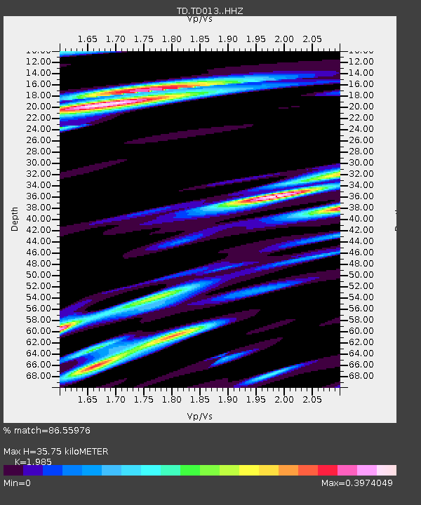
| Estimated Moho Depth: |
35.75 km |
| Estimated Crust Vp/Vs: |
1.99 |
| Assumed Crust Vp: |
6.426 km/s |
| Estimated Crust Vs: |
3.237 km/s |
| Estimated Crust Poisson's Ratio: |
0.33 |
|
| Radial Match: |
86.55976 % |
| Radial Bump: |
400 |
| Transverse Match: |
83.321556 % |
| Transverse Bump: |
400 |
| SOD ConfigId: |
21166931 |
| Insert Time: |
2020-06-14 05:32:48.692 +0000 |
| GWidth: |
2.5 |
| Max Bumps: |
400 |
| Tol: |
0.001 |
|

Signal To Noise
| Channel | StoN | STA | LTA |
| TD:TD013: :HHZ:20200531T05:20:43.850028Z | 11.556513 | 1.3073587E-6 | 1.1312745E-7 |
| TD:TD013: :HH1:20200531T05:20:43.850028Z | 2.0224671 | 2.7399093E-7 | 1.3547361E-7 |
| TD:TD013: :HH2:20200531T05:20:43.850028Z | 2.6141193 | 1.6933983E-7 | 6.4778924E-8 |
| Arrivals |
| Ps | 5.6 SECOND |
| PpPs | 16 SECOND |
| PsPs/PpSs | 22 SECOND |


