You are here: Home > Network List > KN - Kyrgyz Seismic Telemetry Network Stations List
> Station KZA KN.KZA > Earthquake Result Viewer
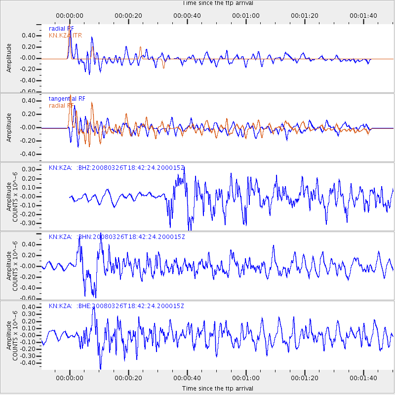
KZA KN.KZA - Earthquake Result Viewer
*The percent match for this event was below the threshold and hence no stack was calculated.
| Earthquake location: |
Kuril Islands |
| Earthquake latitude/longitude: |
46.4/153.0 |
| Earthquake time(UTC): |
2008/03/26 (086) 18:33:34 GMT |
| Earthquake Depth: |
17 km |
| Earthquake Magnitude: |
5.5 MB, 5.2 MS, 5.6 MW, 5.5 MW |
| Earthquake Catalog/Contributor: |
WHDF/NEIC |
|
| Network: |
KN Kyrgyz Seismic Telemetry Network |
| Station: |
KZA KN.KZA |
| Lat/Lon: |
42.08 N/75.25 E |
| Elevation: |
3520 m |
|
| Distance: |
53.7 deg |
| Az: |
295.536 deg |
| Baz: |
56.966 deg |
| Ray Param: |
$rayparam |
*The percent match for this event was below the threshold and hence was not used in the summary stack. |
|
| Radial Match: |
68.63262 % |
| Radial Bump: |
400 |
| Transverse Match: |
66.56621 % |
| Transverse Bump: |
400 |
| SOD ConfigId: |
2504 |
| Insert Time: |
2010-03-08 20:45:25.688 +0000 |
| GWidth: |
2.5 |
| Max Bumps: |
400 |
| Tol: |
0.001 |
|
Signal To Noise
| Channel | StoN | STA | LTA |
| KN:KZA: :BHN:20080326T18:42:24.200015Z | 3.284277 | 2.0772859E-7 | 6.3249416E-8 |
| KN:KZA: :BHE:20080326T18:42:24.200015Z | 0.8213927 | 6.600209E-8 | 8.035387E-8 |
| KN:KZA: :BHZ:20080326T18:42:24.200015Z | 2.3936024 | 9.705165E-8 | 4.054627E-8 |
| Arrivals |
| Ps | |
| PpPs | |
| PsPs/PpSs | |


