You are here: Home > Network List > TX - Texas Seismological Network Stations List
> Station PB21 Reeves Ward Border > Earthquake Result Viewer
PB21 Reeves Ward Border - Earthquake Result Viewer
| Earthquake location: |
Southern Peru |
| Earthquake latitude/longitude: |
-15.3/-70.7 |
| Earthquake time(UTC): |
2020/05/31 (152) 05:09:35 GMT |
| Earthquake Depth: |
153 km |
| Earthquake Magnitude: |
6.0 mww |
| Earthquake Catalog/Contributor: |
NEIC PDE/us |
|
| Network: |
TX Texas Seismological Network |
| Station: |
PB21 Reeves Ward Border |
| Lat/Lon: |
31.34 N/103.06 W |
| Elevation: |
753 m |
|
| Distance: |
55.8 deg |
| Az: |
326.348 deg |
| Baz: |
141.313 deg |
| Ray Param: |
0.064045906 |
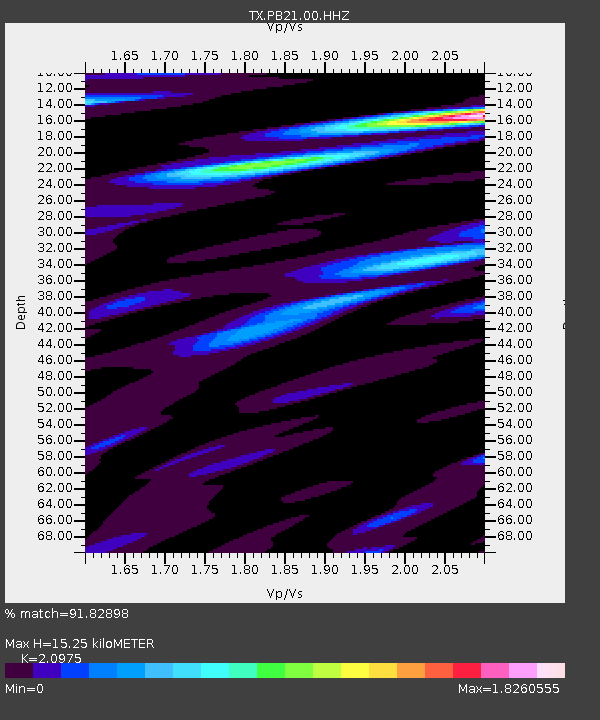
| Estimated Moho Depth: |
15.25 km |
| Estimated Crust Vp/Vs: |
2.10 |
| Assumed Crust Vp: |
6.121 km/s |
| Estimated Crust Vs: |
2.918 km/s |
| Estimated Crust Poisson's Ratio: |
0.35 |
|
| Radial Match: |
91.82898 % |
| Radial Bump: |
376 |
| Transverse Match: |
77.12383 % |
| Transverse Bump: |
400 |
| SOD ConfigId: |
21166931 |
| Insert Time: |
2020-06-14 05:33:58.031 +0000 |
| GWidth: |
2.5 |
| Max Bumps: |
400 |
| Tol: |
0.001 |
|

Signal To Noise
| Channel | StoN | STA | LTA |
| TX:PB21:00:HHZ:20200531T05:18:26.249992Z | 5.424082 | 6.79886E-7 | 1.2534582E-7 |
| TX:PB21:00:HH1:20200531T05:18:26.249992Z | 4.9734974 | 4.0541948E-7 | 8.151598E-8 |
| TX:PB21:00:HH2:20200531T05:18:26.249992Z | 3.5782726 | 4.5725895E-7 | 1.2778762E-7 |
| Arrivals |
| Ps | 2.8 SECOND |
| PpPs | 7.4 SECOND |
| PsPs/PpSs | 10 SECOND |


