You are here: Home > Network List > TX - Texas Seismological Network Stations List
> Station SN07 Snyder 07 > Earthquake Result Viewer
SN07 Snyder 07 - Earthquake Result Viewer
| Earthquake location: |
Southern Peru |
| Earthquake latitude/longitude: |
-15.3/-70.7 |
| Earthquake time(UTC): |
2020/05/31 (152) 05:09:35 GMT |
| Earthquake Depth: |
153 km |
| Earthquake Magnitude: |
6.0 mww |
| Earthquake Catalog/Contributor: |
NEIC PDE/us |
|
| Network: |
TX Texas Seismological Network |
| Station: |
SN07 Snyder 07 |
| Lat/Lon: |
33.09 N/100.89 W |
| Elevation: |
620 m |
|
| Distance: |
56.1 deg |
| Az: |
329.389 deg |
| Baz: |
144.168 deg |
| Ray Param: |
0.06386581 |
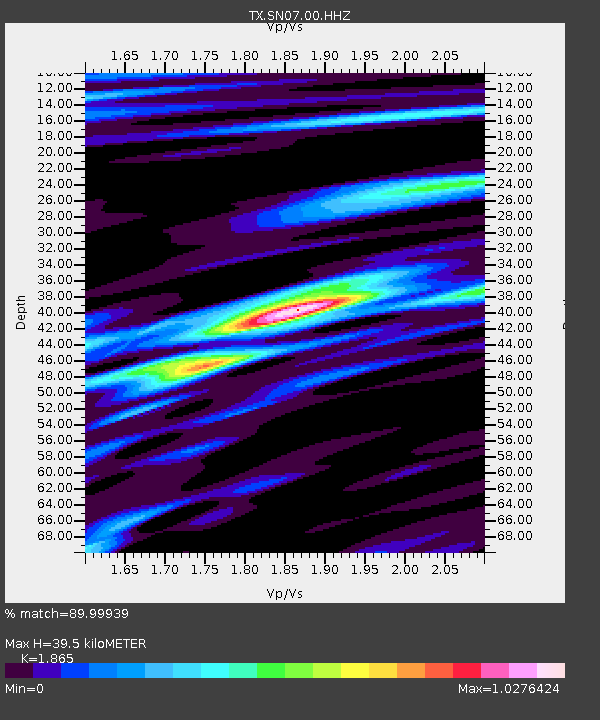
| Estimated Moho Depth: |
39.5 km |
| Estimated Crust Vp/Vs: |
1.87 |
| Assumed Crust Vp: |
6.426 km/s |
| Estimated Crust Vs: |
3.446 km/s |
| Estimated Crust Poisson's Ratio: |
0.30 |
|
| Radial Match: |
89.99939 % |
| Radial Bump: |
327 |
| Transverse Match: |
62.473637 % |
| Transverse Bump: |
400 |
| SOD ConfigId: |
21166931 |
| Insert Time: |
2020-06-14 05:34:15.043 +0000 |
| GWidth: |
2.5 |
| Max Bumps: |
400 |
| Tol: |
0.001 |
|

Signal To Noise
| Channel | StoN | STA | LTA |
| TX:SN07:00:HHZ:20200531T05:18:28.189994Z | 8.36746 | 6.8993484E-7 | 8.245451E-8 |
| TX:SN07:00:HH1:20200531T05:18:28.189994Z | 3.497288 | 2.833676E-7 | 8.102495E-8 |
| TX:SN07:00:HH2:20200531T05:18:28.189994Z | 5.082289 | 1.9503767E-7 | 3.837595E-8 |
| Arrivals |
| Ps | 5.6 SECOND |
| PpPs | 17 SECOND |
| PsPs/PpSs | 22 SECOND |


