You are here: Home > Network List > TX - Texas Seismological Network Stations List
> Station SNAG San Augustine > Earthquake Result Viewer
SNAG San Augustine - Earthquake Result Viewer

| Earthquake location: |
Southern Peru |
| Earthquake latitude/longitude: |
-15.3/-70.7 |
| Earthquake time(UTC): |
2020/05/31 (152) 05:09:35 GMT |
| Earthquake Depth: |
153 km |
| Earthquake Magnitude: |
6.0 mww |
| Earthquake Catalog/Contributor: |
NEIC PDE/us |
|
| Network: |
TX Texas Seismological Network |
| Station: |
SNAG San Augustine |
| Lat/Lon: |
31.52 N/94.18 W |
| Elevation: |
84 m |
|
| Distance: |
51.7 deg |
| Az: |
334.27 deg |
| Baz: |
150.62 deg |
| Ray Param: |
0.06670019 |
| Estimated Moho Depth: |
40.0 km |
| Estimated Crust Vp/Vs: |
1.60 |
| Assumed Crust Vp: |
5.738 km/s |
| Estimated Crust Vs: |
3.587 km/s |
| Estimated Crust Poisson's Ratio: |
0.18 |
|
| Radial Match: |
94.747955 % |
| Radial Bump: |
271 |
| Transverse Match: |
90.011024 % |
| Transverse Bump: |
344 |
| SOD ConfigId: |
21166931 |
| Insert Time: |
2020-06-14 05:34:20.581 +0000 |
| GWidth: |
2.5 |
| Max Bumps: |
400 |
| Tol: |
0.001 |
|
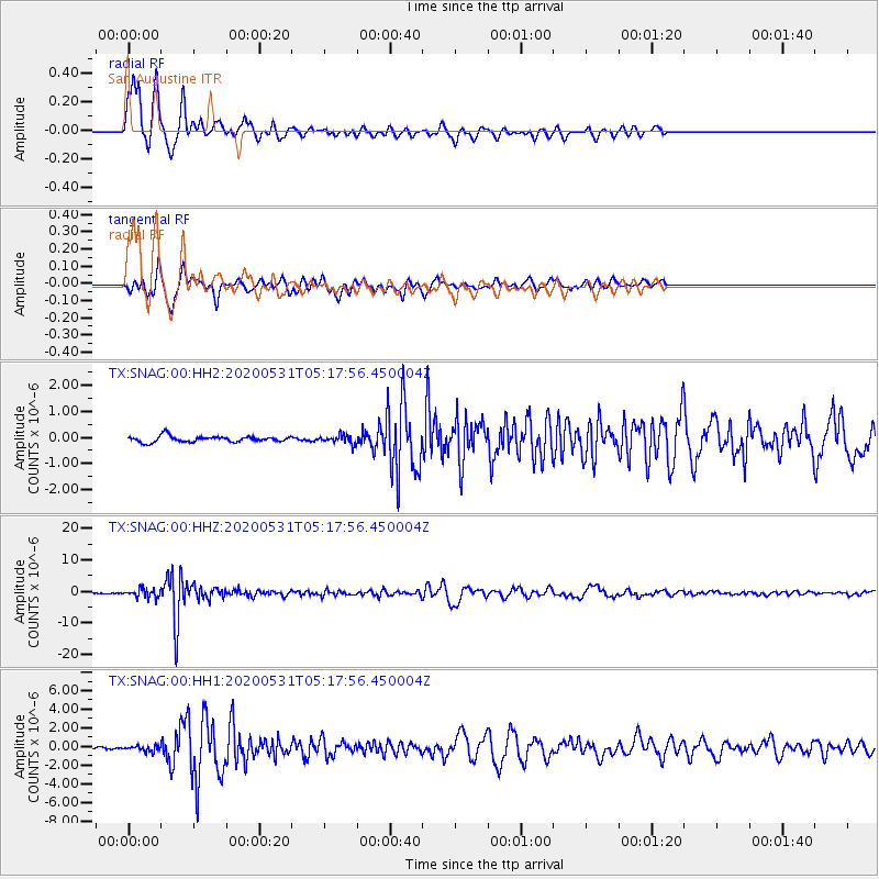
Signal To Noise
| Channel | StoN | STA | LTA |
| TX:SNAG:00:HHZ:20200531T05:17:56.450004Z | 11.440878 | 1.3424099E-6 | 1.1733451E-7 |
| TX:SNAG:00:HH1:20200531T05:17:56.450004Z | 3.1279695 | 2.847725E-7 | 9.104069E-8 |
| TX:SNAG:00:HH2:20200531T05:17:56.450004Z | 1.3897973 | 1.5906288E-7 | 1.1445041E-7 |
| Arrivals |
| Ps | 4.4 SECOND |
| PpPs | 17 SECOND |
| PsPs/PpSs | 22 SECOND |


