You are here: Home > Network List > US - United States National Seismic Network Stations List
> Station HAWA Hanford, Washington, USA > Earthquake Result Viewer
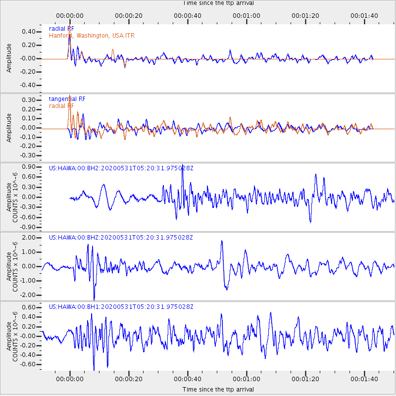
HAWA Hanford, Washington, USA - Earthquake Result Viewer
*The percent match for this event was below the threshold and hence no stack was calculated.
| Earthquake location: |
Southern Peru |
| Earthquake latitude/longitude: |
-15.3/-70.7 |
| Earthquake time(UTC): |
2020/05/31 (152) 05:09:35 GMT |
| Earthquake Depth: |
153 km |
| Earthquake Magnitude: |
6.0 mww |
| Earthquake Catalog/Contributor: |
NEIC PDE/us |
|
| Network: |
US United States National Seismic Network |
| Station: |
HAWA Hanford, Washington, USA |
| Lat/Lon: |
46.39 N/119.53 W |
| Elevation: |
364 m |
|
| Distance: |
75.5 deg |
| Az: |
327.419 deg |
| Baz: |
131.334 deg |
| Ray Param: |
$rayparam |
*The percent match for this event was below the threshold and hence was not used in the summary stack. |
|
| Radial Match: |
70.10816 % |
| Radial Bump: |
400 |
| Transverse Match: |
72.364944 % |
| Transverse Bump: |
400 |
| SOD ConfigId: |
21166931 |
| Insert Time: |
2020-06-14 05:35:16.840 +0000 |
| GWidth: |
2.5 |
| Max Bumps: |
400 |
| Tol: |
0.001 |
|
Signal To Noise
| Channel | StoN | STA | LTA |
| US:HAWA:00:BHZ:20200531T05:20:31.975028Z | 1.8396798 | 3.5152314E-7 | 1.9107843E-7 |
| US:HAWA:00:BH1:20200531T05:20:31.975028Z | 1.7642503 | 1.4901755E-7 | 8.4465086E-8 |
| US:HAWA:00:BH2:20200531T05:20:31.975028Z | 1.0731038 | 1.6138644E-7 | 1.503922E-7 |
| Arrivals |
| Ps | |
| PpPs | |
| PsPs/PpSs | |


