You are here: Home > Network List > TS - TERRAscope (Southern California Seismic Network) Stations List
> Station SVD Seven Oaks Dam, California, USA > Earthquake Result Viewer
SVD Seven Oaks Dam, California, USA - Earthquake Result Viewer
| Earthquake location: |
Southern Peru |
| Earthquake latitude/longitude: |
-16.5/-70.7 |
| Earthquake time(UTC): |
1991/05/24 (144) 20:50:55 GMT |
| Earthquake Depth: |
125 km |
| Earthquake Magnitude: |
6.3 MB, 6.8 UNKNOWN |
| Earthquake Catalog/Contributor: |
WHDF/NEIC |
|
| Network: |
TS TERRAscope (Southern California Seismic Network) |
| Station: |
SVD Seven Oaks Dam, California, USA |
| Lat/Lon: |
34.10 N/117.10 W |
| Elevation: |
600 m |
|
| Distance: |
66.9 deg |
| Az: |
319.241 deg |
| Baz: |
130.983 deg |
| Ray Param: |
0.05695051 |
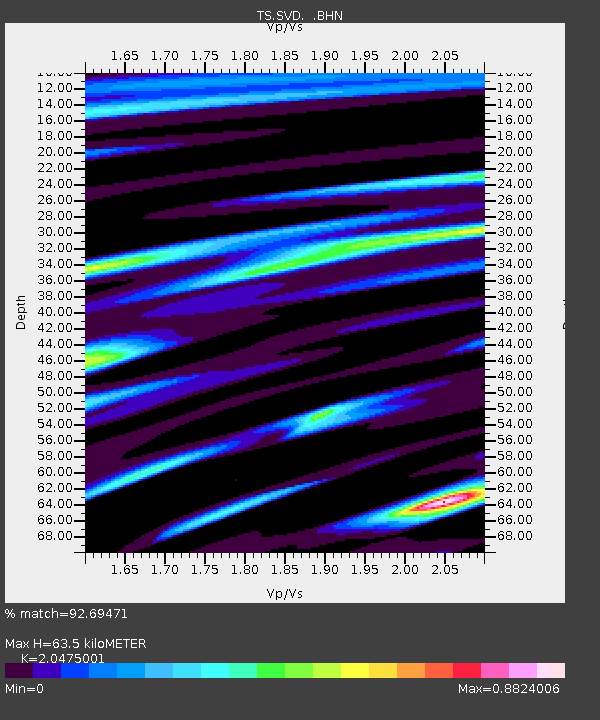
| Estimated Moho Depth: |
63.5 km |
| Estimated Crust Vp/Vs: |
2.05 |
| Assumed Crust Vp: |
6.276 km/s |
| Estimated Crust Vs: |
3.065 km/s |
| Estimated Crust Poisson's Ratio: |
0.34 |
|
| Radial Match: |
92.69471 % |
| Radial Bump: |
400 |
| Transverse Match: |
86.20234 % |
| Transverse Bump: |
400 |
| SOD ConfigId: |
16938 |
| Insert Time: |
2010-02-26 14:52:28.426 +0000 |
| GWidth: |
2.5 |
| Max Bumps: |
400 |
| Tol: |
0.001 |
|

Signal To Noise
| Channel | StoN | STA | LTA |
| TS:SVD: :BHN:19910524T21:01:03.618994Z | 4.348538 | 2.1280123E-6 | 4.8936266E-7 |
| TS:SVD: :BHE:19910524T21:01:03.618994Z | 3.739115 | 1.3755324E-6 | 3.6787645E-7 |
| TS:SVD: :BHZ:19910524T21:01:03.618994Z | 33.644463 | 6.213899E-6 | 1.8469306E-7 |
| Arrivals |
| Ps | 11 SECOND |
| PpPs | 30 SECOND |
| PsPs/PpSs | 41 SECOND |


