You are here: Home > Network List > TS - TERRAscope (Southern California Seismic Network) Stations List
> Station SVD Seven Oaks Dam, California, USA > Earthquake Result Viewer
SVD Seven Oaks Dam, California, USA - Earthquake Result Viewer
| Earthquake location: |
Alaska Peninsula |
| Earthquake latitude/longitude: |
54.5/-161.6 |
| Earthquake time(UTC): |
1991/05/30 (150) 13:17:44 GMT |
| Earthquake Depth: |
47 km |
| Earthquake Magnitude: |
6.2 MB, 6.7 MS, 6.8 UNKNOWN |
| Earthquake Catalog/Contributor: |
WHDF/NEIC |
|
| Network: |
TS TERRAscope (Southern California Seismic Network) |
| Station: |
SVD Seven Oaks Dam, California, USA |
| Lat/Lon: |
34.10 N/117.10 W |
| Elevation: |
600 m |
|
| Distance: |
37.0 deg |
| Az: |
104.984 deg |
| Baz: |
317.263 deg |
| Ray Param: |
0.07625662 |
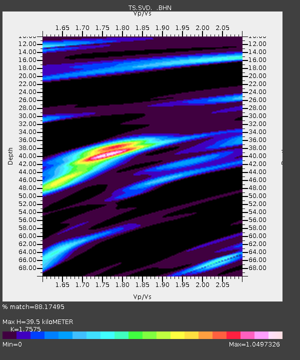
| Estimated Moho Depth: |
39.5 km |
| Estimated Crust Vp/Vs: |
1.76 |
| Assumed Crust Vp: |
6.276 km/s |
| Estimated Crust Vs: |
3.571 km/s |
| Estimated Crust Poisson's Ratio: |
0.26 |
|
| Radial Match: |
88.17495 % |
| Radial Bump: |
400 |
| Transverse Match: |
77.21519 % |
| Transverse Bump: |
400 |
| SOD ConfigId: |
16938 |
| Insert Time: |
2010-02-26 14:52:29.452 +0000 |
| GWidth: |
2.5 |
| Max Bumps: |
400 |
| Tol: |
0.001 |
|
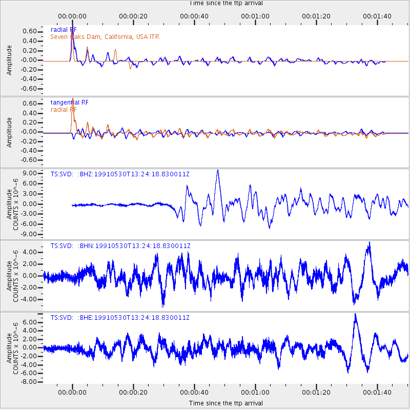
Signal To Noise
| Channel | StoN | STA | LTA |
| TS:SVD: :BHN:19910530T13:24:18.830011Z | 1.6551032 | 7.8056763E-7 | 4.7161265E-7 |
| TS:SVD: :BHE:19910530T13:24:18.830011Z | 1.8789046 | 7.8033946E-7 | 4.1531618E-7 |
| TS:SVD: :BHZ:19910530T13:24:18.830011Z | 7.6209445 | 1.4420067E-6 | 1.8921627E-7 |
| Arrivals |
| Ps | 5.1 SECOND |
| PpPs | 16 SECOND |
| PsPs/PpSs | 21 SECOND |


