You are here: Home > Network List > TS - TERRAscope (Southern California Seismic Network) Stations List
> Station SVD Seven Oaks Dam, California, USA > Earthquake Result Viewer
SVD Seven Oaks Dam, California, USA - Earthquake Result Viewer

| Earthquake location: |
Alaska Peninsula |
| Earthquake latitude/longitude: |
55.2/-160.5 |
| Earthquake time(UTC): |
1993/05/13 (133) 11:59:49 GMT |
| Earthquake Depth: |
32 km |
| Earthquake Magnitude: |
6.4 MB, 6.8 MS, 6.8 UNKNOWN |
| Earthquake Catalog/Contributor: |
WHDF/NEIC |
|
| Network: |
TS TERRAscope (Southern California Seismic Network) |
| Station: |
SVD Seven Oaks Dam, California, USA |
| Lat/Lon: |
34.10 N/117.10 W |
| Elevation: |
600 m |
|
| Distance: |
36.6 deg |
| Az: |
106.983 deg |
| Baz: |
318.611 deg |
| Ray Param: |
0.07655498 |
| Estimated Moho Depth: |
16.5 km |
| Estimated Crust Vp/Vs: |
1.76 |
| Assumed Crust Vp: |
6.276 km/s |
| Estimated Crust Vs: |
3.566 km/s |
| Estimated Crust Poisson's Ratio: |
0.26 |
|
| Radial Match: |
84.31521 % |
| Radial Bump: |
399 |
| Transverse Match: |
71.93876 % |
| Transverse Bump: |
400 |
| SOD ConfigId: |
16938 |
| Insert Time: |
2010-02-26 14:52:31.172 +0000 |
| GWidth: |
2.5 |
| Max Bumps: |
400 |
| Tol: |
0.001 |
|
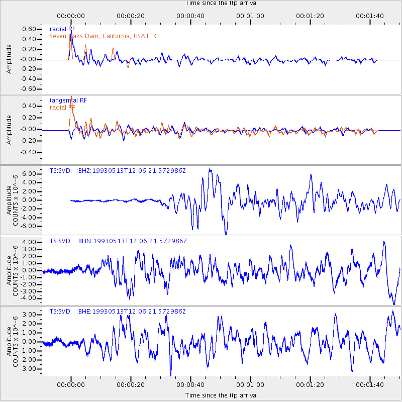
Signal To Noise
| Channel | StoN | STA | LTA |
| TS:SVD: :BHN:19930513T12:06:21.572986Z | 2.0106125 | 3.6811213E-7 | 1.8308458E-7 |
| TS:SVD: :BHE:19930513T12:06:21.572986Z | 0.6615883 | 2.8123145E-7 | 4.250853E-7 |
| TS:SVD: :BHZ:19930513T12:06:21.572986Z | 6.008275 | 9.1087423E-7 | 1.5160329E-7 |
| Arrivals |
| Ps | 2.1 SECOND |
| PpPs | 6.8 SECOND |
| PsPs/PpSs | 8.9 SECOND |


