You are here: Home > Network List > CI - Caltech Regional Seismic Network Stations List
> Station MPM Manuel Prospect Mine, California, USA > Earthquake Result Viewer
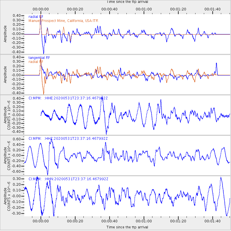
MPM Manuel Prospect Mine, California, USA - Earthquake Result Viewer
*The percent match for this event was below the threshold and hence no stack was calculated.
| Earthquake location: |
South Of Fiji Islands |
| Earthquake latitude/longitude: |
-23.9/-176.6 |
| Earthquake time(UTC): |
2020/05/31 (152) 23:25:40 GMT |
| Earthquake Depth: |
100 km |
| Earthquake Magnitude: |
5.6 mww |
| Earthquake Catalog/Contributor: |
NEIC PDE/us |
|
| Network: |
CI Caltech Regional Seismic Network |
| Station: |
MPM Manuel Prospect Mine, California, USA |
| Lat/Lon: |
36.06 N/117.49 W |
| Elevation: |
185 m |
|
| Distance: |
81.6 deg |
| Az: |
44.635 deg |
| Baz: |
232.539 deg |
| Ray Param: |
$rayparam |
*The percent match for this event was below the threshold and hence was not used in the summary stack. |
|
| Radial Match: |
84.45755 % |
| Radial Bump: |
400 |
| Transverse Match: |
64.44329 % |
| Transverse Bump: |
400 |
| SOD ConfigId: |
21166931 |
| Insert Time: |
2020-06-14 23:33:06.561 +0000 |
| GWidth: |
2.5 |
| Max Bumps: |
400 |
| Tol: |
0.001 |
|
Signal To Noise
| Channel | StoN | STA | LTA |
| CI:MPM: :HHZ:20200531T23:37:16.467992Z | 3.2713046 | 4.0628657E-7 | 1.241971E-7 |
| CI:MPM: :HHN:20200531T23:37:16.467992Z | 1.376004 | 1.9140653E-7 | 1.3910318E-7 |
| CI:MPM: :HHE:20200531T23:37:16.467992Z | 1.1895632 | 1.4321805E-7 | 1.2039548E-7 |
| Arrivals |
| Ps | |
| PpPs | |
| PsPs/PpSs | |


