You are here: Home > Network List > IU - Global Seismograph Network (GSN - IRIS/USGS) Stations List
> Station PMG Port Moresby, New Guinea > Earthquake Result Viewer
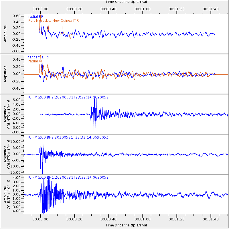
PMG Port Moresby, New Guinea - Earthquake Result Viewer
*The percent match for this event was below the threshold and hence no stack was calculated.
| Earthquake location: |
South Of Fiji Islands |
| Earthquake latitude/longitude: |
-23.9/-176.6 |
| Earthquake time(UTC): |
2020/05/31 (152) 23:25:40 GMT |
| Earthquake Depth: |
100 km |
| Earthquake Magnitude: |
5.6 mww |
| Earthquake Catalog/Contributor: |
NEIC PDE/us |
|
| Network: |
IU Global Seismograph Network (GSN - IRIS/USGS) |
| Station: |
PMG Port Moresby, New Guinea |
| Lat/Lon: |
9.40 S/147.16 E |
| Elevation: |
90 m |
|
| Distance: |
37.5 deg |
| Az: |
286.37 deg |
| Baz: |
117.107 deg |
| Ray Param: |
$rayparam |
*The percent match for this event was below the threshold and hence was not used in the summary stack. |
|
| Radial Match: |
77.22673 % |
| Radial Bump: |
400 |
| Transverse Match: |
71.77171 % |
| Transverse Bump: |
400 |
| SOD ConfigId: |
21166931 |
| Insert Time: |
2020-06-14 23:35:53.182 +0000 |
| GWidth: |
2.5 |
| Max Bumps: |
400 |
| Tol: |
0.001 |
|
Signal To Noise
| Channel | StoN | STA | LTA |
| IU:PMG:00:BHZ:20200531T23:32:14.069005Z | 28.965336 | 4.902284E-6 | 1.6924659E-7 |
| IU:PMG:00:BH1:20200531T23:32:14.069005Z | 18.240892 | 2.4246733E-6 | 1.3292515E-7 |
| IU:PMG:00:BH2:20200531T23:32:14.069005Z | 16.932447 | 2.6539224E-6 | 1.567359E-7 |
| Arrivals |
| Ps | |
| PpPs | |
| PsPs/PpSs | |


