You are here: Home > Network List > US - United States National Seismic Network Stations List
> Station MNTX Cornudas Mountains, Texas, USA > Earthquake Result Viewer
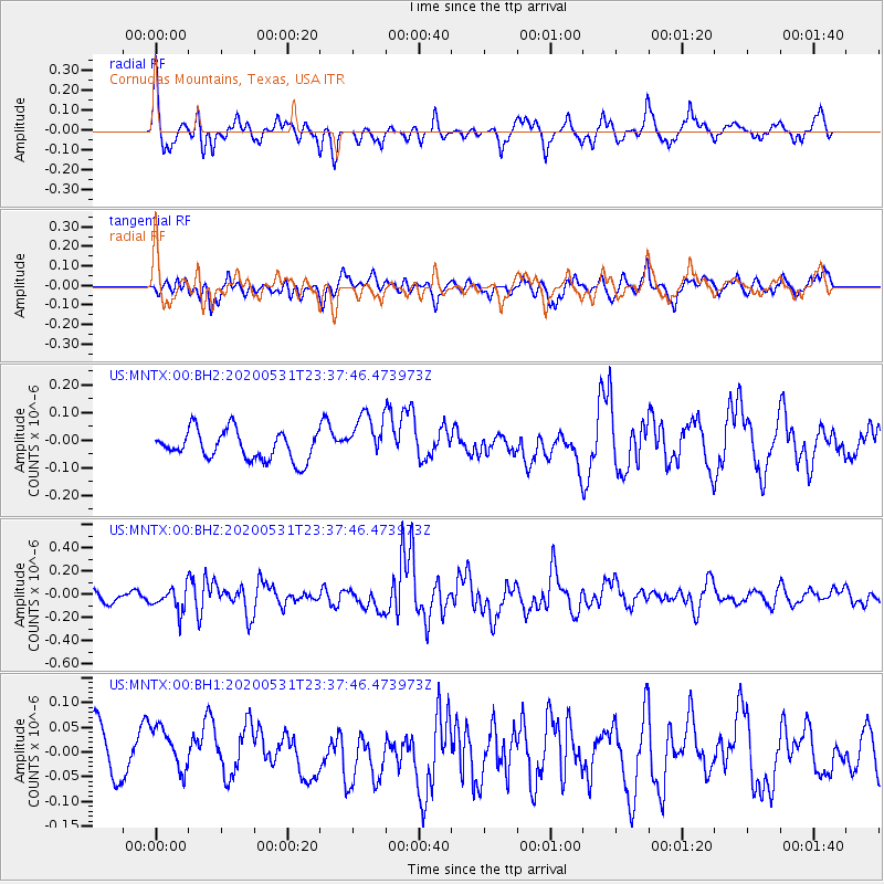
MNTX Cornudas Mountains, Texas, USA - Earthquake Result Viewer
*The percent match for this event was below the threshold and hence no stack was calculated.
| Earthquake location: |
South Of Fiji Islands |
| Earthquake latitude/longitude: |
-23.9/-176.6 |
| Earthquake time(UTC): |
2020/05/31 (152) 23:25:40 GMT |
| Earthquake Depth: |
100 km |
| Earthquake Magnitude: |
5.6 mww |
| Earthquake Catalog/Contributor: |
NEIC PDE/us |
|
| Network: |
US United States National Seismic Network |
| Station: |
MNTX Cornudas Mountains, Texas, USA |
| Lat/Lon: |
31.70 N/105.38 W |
| Elevation: |
404 m |
|
| Distance: |
87.6 deg |
| Az: |
53.855 deg |
| Baz: |
240.144 deg |
| Ray Param: |
$rayparam |
*The percent match for this event was below the threshold and hence was not used in the summary stack. |
|
| Radial Match: |
64.727875 % |
| Radial Bump: |
400 |
| Transverse Match: |
56.16029 % |
| Transverse Bump: |
400 |
| SOD ConfigId: |
21166931 |
| Insert Time: |
2020-06-14 23:43:25.333 +0000 |
| GWidth: |
2.5 |
| Max Bumps: |
400 |
| Tol: |
0.001 |
|
Signal To Noise
| Channel | StoN | STA | LTA |
| US:MNTX:00:BHZ:20200531T23:37:46.473973Z | 1.0989099 | 9.9635535E-8 | 9.066761E-8 |
| US:MNTX:00:BH1:20200531T23:37:46.473973Z | 0.82583535 | 5.0523443E-8 | 6.117859E-8 |
| US:MNTX:00:BH2:20200531T23:37:46.473973Z | 1.6468493 | 8.606045E-8 | 5.225764E-8 |
| Arrivals |
| Ps | |
| PpPs | |
| PsPs/PpSs | |


