You are here: Home > Network List > UW - Pacific Northwest Regional Seismic Network Stations List
> Station UMAT Pilot Rock, OR, USA > Earthquake Result Viewer
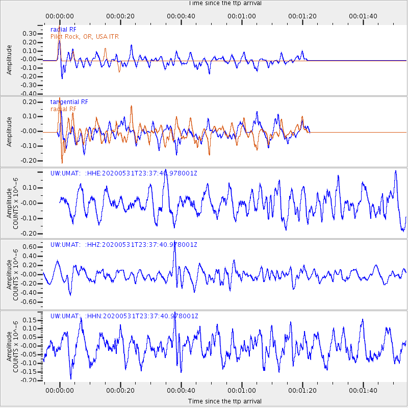
UMAT Pilot Rock, OR, USA - Earthquake Result Viewer
*The percent match for this event was below the threshold and hence no stack was calculated.
| Earthquake location: |
South Of Fiji Islands |
| Earthquake latitude/longitude: |
-23.9/-176.6 |
| Earthquake time(UTC): |
2020/05/31 (152) 23:25:40 GMT |
| Earthquake Depth: |
100 km |
| Earthquake Magnitude: |
5.6 mww |
| Earthquake Catalog/Contributor: |
NEIC PDE/us |
|
| Network: |
UW Pacific Northwest Regional Seismic Network |
| Station: |
UMAT Pilot Rock, OR, USA |
| Lat/Lon: |
45.29 N/118.96 W |
| Elevation: |
1318 m |
|
| Distance: |
86.5 deg |
| Az: |
36.667 deg |
| Baz: |
230.756 deg |
| Ray Param: |
$rayparam |
*The percent match for this event was below the threshold and hence was not used in the summary stack. |
|
| Radial Match: |
61.54469 % |
| Radial Bump: |
348 |
| Transverse Match: |
56.368515 % |
| Transverse Bump: |
351 |
| SOD ConfigId: |
21166931 |
| Insert Time: |
2020-06-14 23:44:31.541 +0000 |
| GWidth: |
2.5 |
| Max Bumps: |
400 |
| Tol: |
0.001 |
|
Signal To Noise
| Channel | StoN | STA | LTA |
| UW:UMAT: :HHZ:20200531T23:37:40.978001Z | 1.9982215 | 2.1232135E-7 | 1.0625516E-7 |
| UW:UMAT: :HHN:20200531T23:37:40.978001Z | 0.94005543 | 7.9837896E-8 | 8.492892E-8 |
| UW:UMAT: :HHE:20200531T23:37:40.978001Z | 1.7042109 | 9.774341E-8 | 5.735406E-8 |
| Arrivals |
| Ps | |
| PpPs | |
| PsPs/PpSs | |


