You are here: Home > Network List > AE - Arizona Broadband Seismic Network Stations List
> Station 113A Mohawk Valley, Roll, AZ, USA > Earthquake Result Viewer
113A Mohawk Valley, Roll, AZ, USA - Earthquake Result Viewer
| Earthquake location: |
Northern Chile |
| Earthquake latitude/longitude: |
-23.4/-68.5 |
| Earthquake time(UTC): |
2020/06/03 (155) 07:35:34 GMT |
| Earthquake Depth: |
138 km |
| Earthquake Magnitude: |
6.8 Mi |
| Earthquake Catalog/Contributor: |
NEIC PDE/at |
|
| Network: |
AE Arizona Broadband Seismic Network |
| Station: |
113A Mohawk Valley, Roll, AZ, USA |
| Lat/Lon: |
32.77 N/113.77 W |
| Elevation: |
118 m |
|
| Distance: |
70.6 deg |
| Az: |
320.616 deg |
| Baz: |
136.219 deg |
| Ray Param: |
0.054510824 |
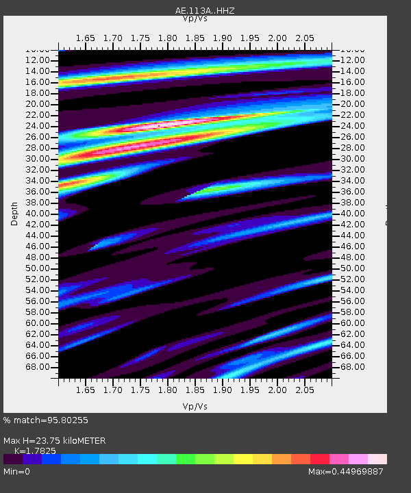
| Estimated Moho Depth: |
23.75 km |
| Estimated Crust Vp/Vs: |
1.78 |
| Assumed Crust Vp: |
6.264 km/s |
| Estimated Crust Vs: |
3.514 km/s |
| Estimated Crust Poisson's Ratio: |
0.27 |
|
| Radial Match: |
95.80255 % |
| Radial Bump: |
400 |
| Transverse Match: |
87.65044 % |
| Transverse Bump: |
400 |
| SOD ConfigId: |
21166931 |
| Insert Time: |
2020-06-17 07:36:12.739 +0000 |
| GWidth: |
2.5 |
| Max Bumps: |
400 |
| Tol: |
0.001 |
|

Signal To Noise
| Channel | StoN | STA | LTA |
| AE:113A: :HHZ:20200603T07:46:03.450012Z | 1.8949732 | 2.1871978E-7 | 1.15421045E-7 |
| AE:113A: :HHN:20200603T07:46:03.450012Z | 1.9848589 | 8.93841E-8 | 4.5032976E-8 |
| AE:113A: :HHE:20200603T07:46:03.450012Z | 0.5150251 | 6.947739E-8 | 1.3490097E-7 |
| Arrivals |
| Ps | 3.1 SECOND |
| PpPs | 10 SECOND |
| PsPs/PpSs | 13 SECOND |


