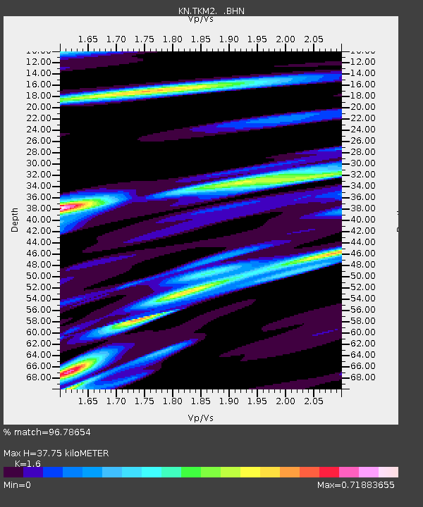
TKM2 KN.TKM2 - Earthquake Result Viewer
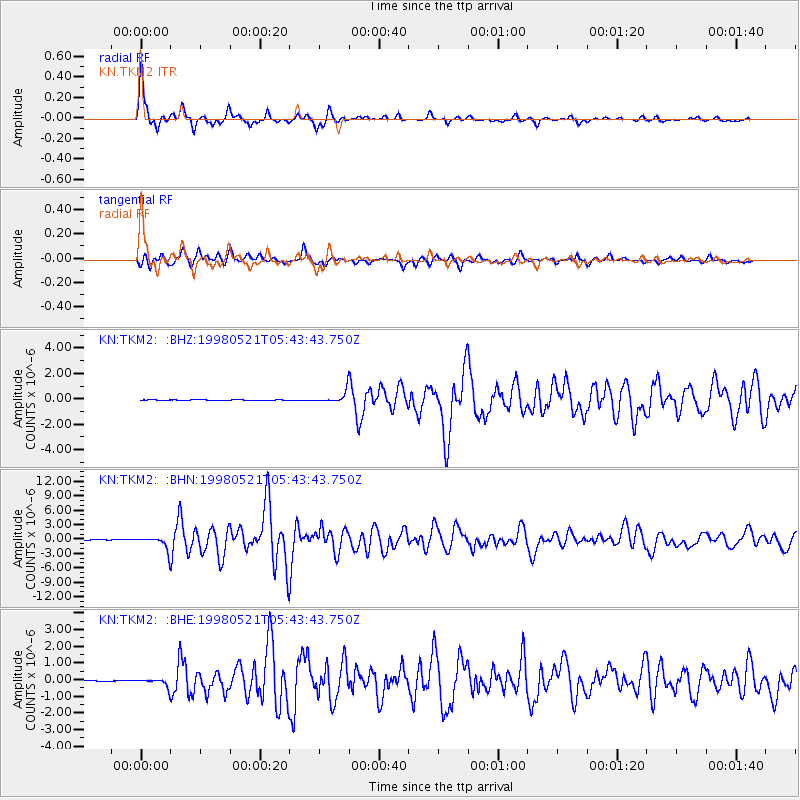
Earthquake location: Minahassa Peninsula, Sulawesi
Earthquake latitude/longitude: 0.2/119.6
Earthquake time(UTC): 1998/05/21 (141) 05:34:25 GMT
Earthquake Depth: 33 km
Earthquake Magnitude: 6.2 MB, 6.3 MS, 6.6 UNKNOWN, 6.6 MW
Earthquake Catalog/Contributor: WHDF/NEIC
Network: KN Kyrgyz Seismic Telemetry Network
Station: TKM2 KN.TKM2
Lat/Lon: 42.92 N/75.60 E
Elevation: 2020 m
Distance: 57.9 deg
Az: 322.985 deg
Baz: 124.959 deg
Ray Param: 0.063117646
Estimated Moho Depth: 37.75 km
Estimated Crust Vp/Vs: 1.60
Assumed Crust Vp: 6.306 km/s
Estimated Crust Vs: 3.941 km/s
Estimated Crust Poisson's Ratio: 0.18
Radial Match: 96.78654 %
Radial Bump: 400
Transverse Match: 92.141815 %
Transverse Bump: 400
SOD ConfigId: 4480
Insert Time: 2010-03-08 20:47:08.060 +0000
GWidth: 2.5
Max Bumps: 400
Tol: 0.001

Signal To Noise

ChannelStoNSTALTA
KN:TKM2: :BHN:19980521T05:43:43.750Z27.400371.3642763E-64.9790433E-8
KN:TKM2: :BHE:19980521T05:43:43.750Z8.5755772.3468469E-72.7366637E-8
KN:TKM2: :BHZ:19980521T05:43:43.750Z23.256574.5943446E-71.9755038E-8
Arrivals
Ps3.8 SECOND
PpPs15 SECOND
PsPs/PpSs19 SECOND