You are here: Home > Network List > TS - TERRAscope (Southern California Seismic Network) Stations List
> Station SVD Seven Oaks Dam, California, USA > Earthquake Result Viewer
SVD Seven Oaks Dam, California, USA - Earthquake Result Viewer
| Earthquake location: |
South Pacific Ocean |
| Earthquake latitude/longitude: |
-10.8/-128.8 |
| Earthquake time(UTC): |
1994/02/12 (043) 04:16:26 GMT |
| Earthquake Depth: |
10 km |
| Earthquake Magnitude: |
6.3 MB, 6.5 MS, 6.6 UNKNOWN, 6.6 MW |
| Earthquake Catalog/Contributor: |
WHDF/NEIC |
|
| Network: |
TS TERRAscope (Southern California Seismic Network) |
| Station: |
SVD Seven Oaks Dam, California, USA |
| Lat/Lon: |
34.10 N/117.10 W |
| Elevation: |
600 m |
|
| Distance: |
46.0 deg |
| Az: |
13.561 deg |
| Baz: |
196.122 deg |
| Ray Param: |
0.070912786 |
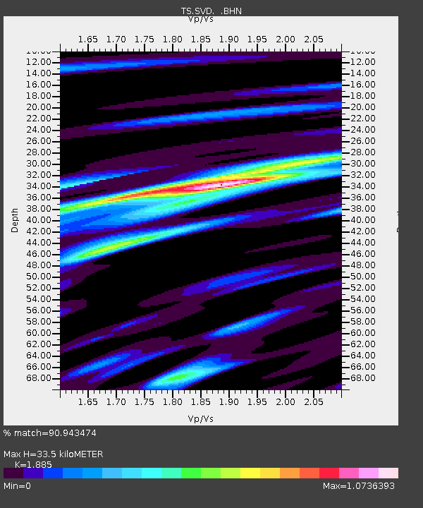
| Estimated Moho Depth: |
33.5 km |
| Estimated Crust Vp/Vs: |
1.88 |
| Assumed Crust Vp: |
6.276 km/s |
| Estimated Crust Vs: |
3.329 km/s |
| Estimated Crust Poisson's Ratio: |
0.30 |
|
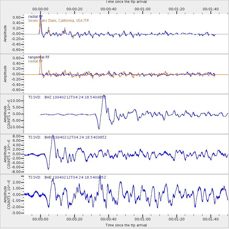
| Radial Match: |
90.943474 % |
| Radial Bump: |
400 |
| Transverse Match: |
75.49981 % |
| Transverse Bump: |
400 |
| SOD ConfigId: |
16938 |
| Insert Time: |
2010-02-26 14:52:38.468 +0000 |
| GWidth: |
2.5 |
| Max Bumps: |
400 |
| Tol: |
0.001 |
|
Signal To Noise
| Channel | StoN | STA | LTA |
| TS:SVD: :BHN:19940212T04:24:18.540985Z | 9.888958 | 2.5715344E-6 | 2.6004096E-7 |
| TS:SVD: :BHE:19940212T04:24:18.540985Z | 2.6395667 | 6.8197494E-7 | 2.5836624E-7 |
| TS:SVD: :BHZ:19940212T04:24:18.540985Z | 17.4108 | 4.5935662E-6 | 2.638343E-7 |
| Arrivals |
| Ps | 5.0 SECOND |
| PpPs | 15 SECOND |
| PsPs/PpSs | 20 SECOND |


