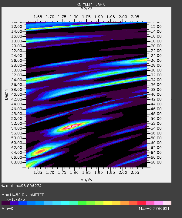
TKM2 KN.TKM2 - Earthquake Result Viewer
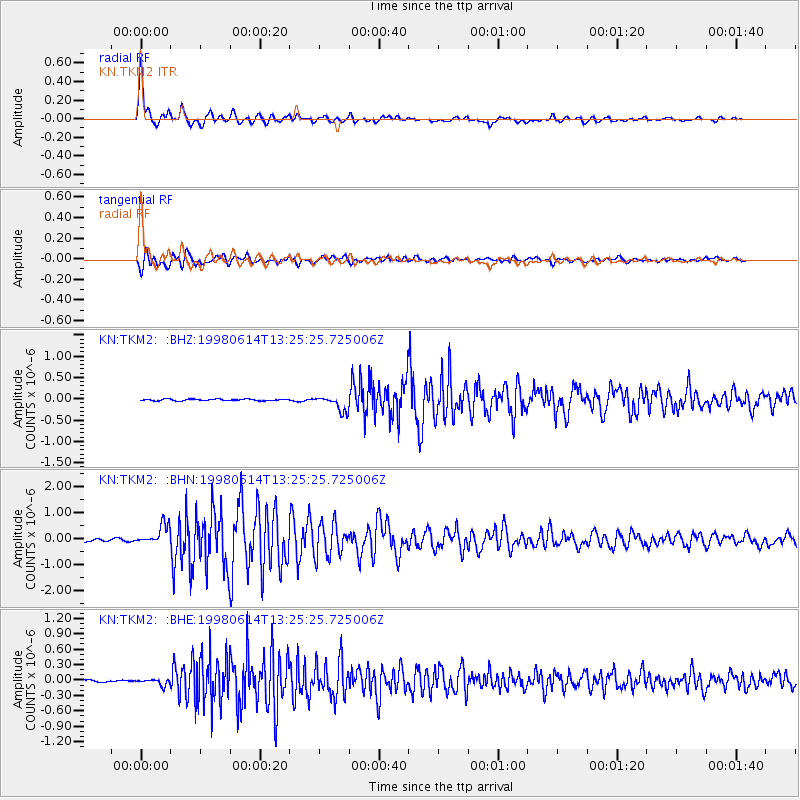
Earthquake location: Near East Coast Of Honshu, Japan
Earthquake latitude/longitude: 35.4/140.5
Earthquake time(UTC): 1998/06/14 (165) 13:17:08 GMT
Earthquake Depth: 45 km
Earthquake Magnitude: 5.5 MB, 5.3 MS, 5.8 UNKNOWN, 5.8 MW
Earthquake Catalog/Contributor: WHDF/NEIC
Network: KN Kyrgyz Seismic Telemetry Network
Station: TKM2 KN.TKM2
Lat/Lon: 42.92 N/75.60 E
Elevation: 2020 m
Distance: 49.8 deg
Az: 299.413 deg
Baz: 75.727 deg
Ray Param: 0.068364844
Estimated Moho Depth: 53.0 km
Estimated Crust Vp/Vs: 1.79
Assumed Crust Vp: 6.306 km/s
Estimated Crust Vs: 3.528 km/s
Estimated Crust Poisson's Ratio: 0.27
Radial Match: 96.806274 %
Radial Bump: 400
Transverse Match: 91.747696 %
Transverse Bump: 400
SOD ConfigId: 4480
Insert Time: 2010-03-08 20:47:18.100 +0000
GWidth: 2.5
Max Bumps: 400
Tol: 0.001

Signal To Noise

ChannelStoNSTALTA
KN:TKM2: :BHN:19980614T13:25:25.725006Z9.0884223.824146E-74.2077122E-8
KN:TKM2: :BHE:19980614T13:25:25.725006Z2.74724916.0016106E-82.184589E-8
KN:TKM2: :BHZ:19980614T13:25:25.725006Z9.8044291.8256704E-71.8620874E-8
Arrivals
Ps7.0 SECOND
PpPs22 SECOND
PsPs/PpSs29 SECOND