You are here: Home > Network List > N4 - Central and EAstern US Network Stations List
> Station SUSD Miller, SD, USA > Earthquake Result Viewer
SUSD Miller, SD, USA - Earthquake Result Viewer
| Earthquake location: |
Northern Chile |
| Earthquake latitude/longitude: |
-23.4/-68.5 |
| Earthquake time(UTC): |
2020/06/03 (155) 07:35:34 GMT |
| Earthquake Depth: |
138 km |
| Earthquake Magnitude: |
6.8 Mi |
| Earthquake Catalog/Contributor: |
NEIC PDE/at |
|
| Network: |
N4 Central and EAstern US Network |
| Station: |
SUSD Miller, SD, USA |
| Lat/Lon: |
44.44 N/98.96 W |
| Elevation: |
520 m |
|
| Distance: |
73.0 deg |
| Az: |
337.692 deg |
| Baz: |
150.866 deg |
| Ray Param: |
0.052919533 |
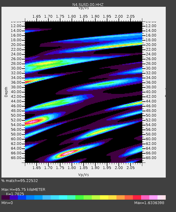
| Estimated Moho Depth: |
65.75 km |
| Estimated Crust Vp/Vs: |
1.78 |
| Assumed Crust Vp: |
6.53 km/s |
| Estimated Crust Vs: |
3.664 km/s |
| Estimated Crust Poisson's Ratio: |
0.27 |
|
| Radial Match: |
95.22532 % |
| Radial Bump: |
364 |
| Transverse Match: |
74.972046 % |
| Transverse Bump: |
400 |
| SOD ConfigId: |
21166931 |
| Insert Time: |
2020-06-17 07:45:15.607 +0000 |
| GWidth: |
2.5 |
| Max Bumps: |
400 |
| Tol: |
0.001 |
|

Signal To Noise
| Channel | StoN | STA | LTA |
| N4:SUSD:00:HHZ:20200603T07:46:17.929993Z | 2.1687193 | 2.5221965E-7 | 1.162989E-7 |
| N4:SUSD:00:HH1:20200603T07:46:17.929993Z | 1.2523954 | 1.7088637E-7 | 1.3644762E-7 |
| N4:SUSD:00:HH2:20200603T07:46:17.929993Z | 0.814216 | 1.0538838E-7 | 1.294354E-7 |
| Arrivals |
| Ps | 8.2 SECOND |
| PpPs | 27 SECOND |
| PsPs/PpSs | 35 SECOND |


