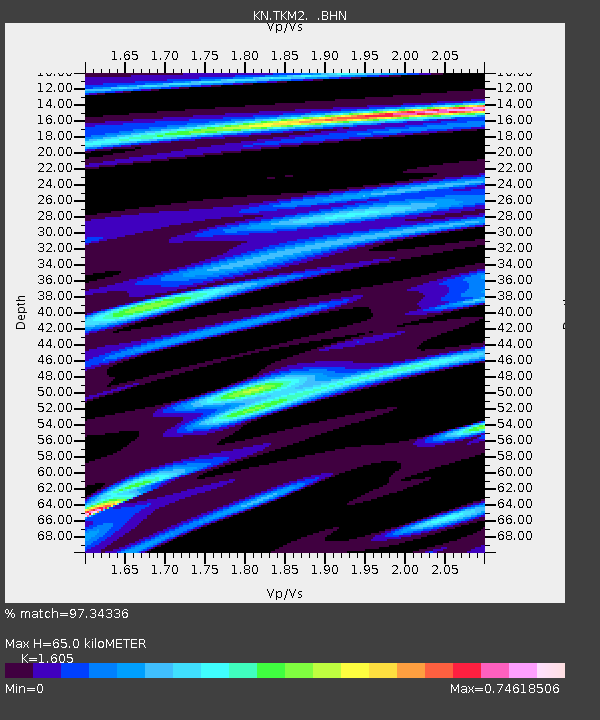
TKM2 KN.TKM2 - Earthquake Result Viewer
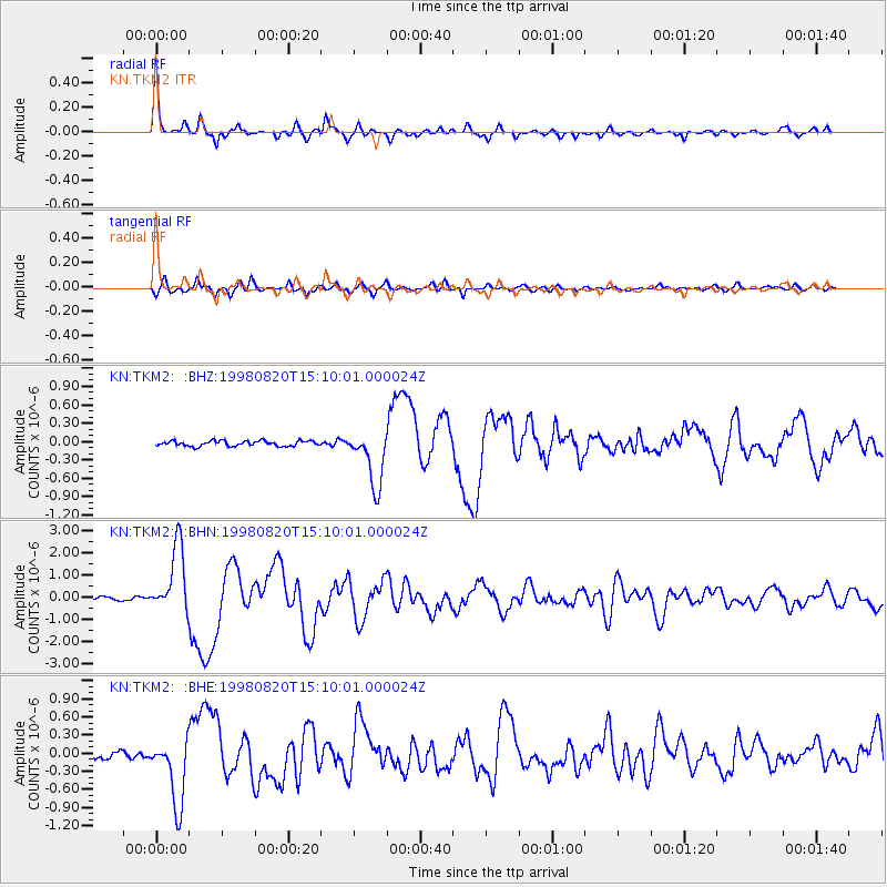
Earthquake location: Rat Islands, Aleutian Islands
Earthquake latitude/longitude: 51.6/175.2
Earthquake time(UTC): 1998/08/20 (232) 15:00:08 GMT
Earthquake Depth: 33 km
Earthquake Magnitude: 5.6 MB, 6.0 MS, 6.2 UNKNOWN, 6.2 MW
Earthquake Catalog/Contributor: WHDF/NEIC
Network: KN Kyrgyz Seismic Telemetry Network
Station: TKM2 KN.TKM2
Lat/Lon: 42.92 N/75.60 E
Elevation: 2020 m
Distance: 63.0 deg
Az: 305.645 deg
Baz: 43.608 deg
Ray Param: 0.05979589
Estimated Moho Depth: 65.0 km
Estimated Crust Vp/Vs: 1.61
Assumed Crust Vp: 6.306 km/s
Estimated Crust Vs: 3.929 km/s
Estimated Crust Poisson's Ratio: 0.18
Radial Match: 97.34336 %
Radial Bump: 344
Transverse Match: 91.635376 %
Transverse Bump: 400
SOD ConfigId: 4480
Insert Time: 2010-03-08 20:47:50.482 +0000
GWidth: 2.5
Max Bumps: 400
Tol: 0.001

Signal To Noise

ChannelStoNSTALTA
KN:TKM2: :BHN:19980820T15:10:01.000024Z19.6595061.5162287E-67.7124454E-8
KN:TKM2: :BHE:19980820T15:10:01.000024Z11.9522725.6049475E-74.689441E-8
KN:TKM2: :BHZ:19980820T15:10:01.000024Z10.8141544.6041765E-74.257547E-8
Arrivals
Ps6.5 SECOND
PpPs26 SECOND
PsPs/PpSs32 SECOND