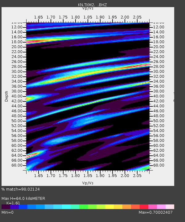
TKM2 KN.TKM2 - Earthquake Result Viewer
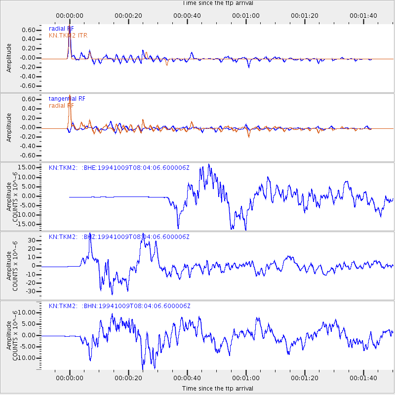
Earthquake location: Kuril Islands
Earthquake latitude/longitude: 43.9/147.9
Earthquake time(UTC): 1994/10/09 (282) 07:55:38 GMT
Earthquake Depth: 23 km
Earthquake Magnitude: 6.5 MB, 7.0 MS, 6.7 UNKNOWN, 7.3 MW
Earthquake Catalog/Contributor: WHDF/NEIC
Network: KN Kyrgyz Seismic Telemetry Network
Station: TKM2 KN.TKM2
Lat/Lon: 42.92 N/75.60 E
Elevation: 2020 m
Distance: 50.9 deg
Az: 295.663 deg
Baz: 62.501 deg
Ray Param: 0.067696474
Estimated Moho Depth: 64.0 km
Estimated Crust Vp/Vs: 1.61
Assumed Crust Vp: 6.306 km/s
Estimated Crust Vs: 3.917 km/s
Estimated Crust Poisson's Ratio: 0.19
Radial Match: 98.02124 %
Radial Bump: 398
Transverse Match: 92.20602 %
Transverse Bump: 400
SOD ConfigId: 4480
Insert Time: 2010-03-08 20:47:58.624 +0000
GWidth: 2.5
Max Bumps: 400
Tol: 0.001

Signal To Noise

ChannelStoNSTALTA
KN:TKM2: :BHZ:19941009T08:04:06.600006Z35.916433.6279737E-61.0101153E-7
KN:TKM2: :BHN:19941009T08:04:06.600006Z22.7496871.113178E-64.893157E-8
KN:TKM2: :BHE:19941009T08:04:06.600006Z17.5040421.4970515E-68.552604E-8
Arrivals
Ps6.6 SECOND
PpPs25 SECOND
PsPs/PpSs32 SECOND